
Drifter Bay
|
Areas Page Editors: please follow the Guidelines, whether you are editing an in-game area or World Territory. |
On this page... (hide)
- 1. Description
- 2. Subterritories
- 3. Landmarks
- 4. Waterways
- 4.1 Chignecto Bay
- 4.2 Minas Basin
- 4.3 Newville Lake (Salsola)
- 4.4 Pictou River
- 4.5 Parrsboro Harbour (aka Sal Palus)
- 5. Islands
- 5.1 Five Islands
- 6. Likely Encounters
- 7. History
- 8. Sources
 | |
| Credit | msprague@Flickr |
|
General | |
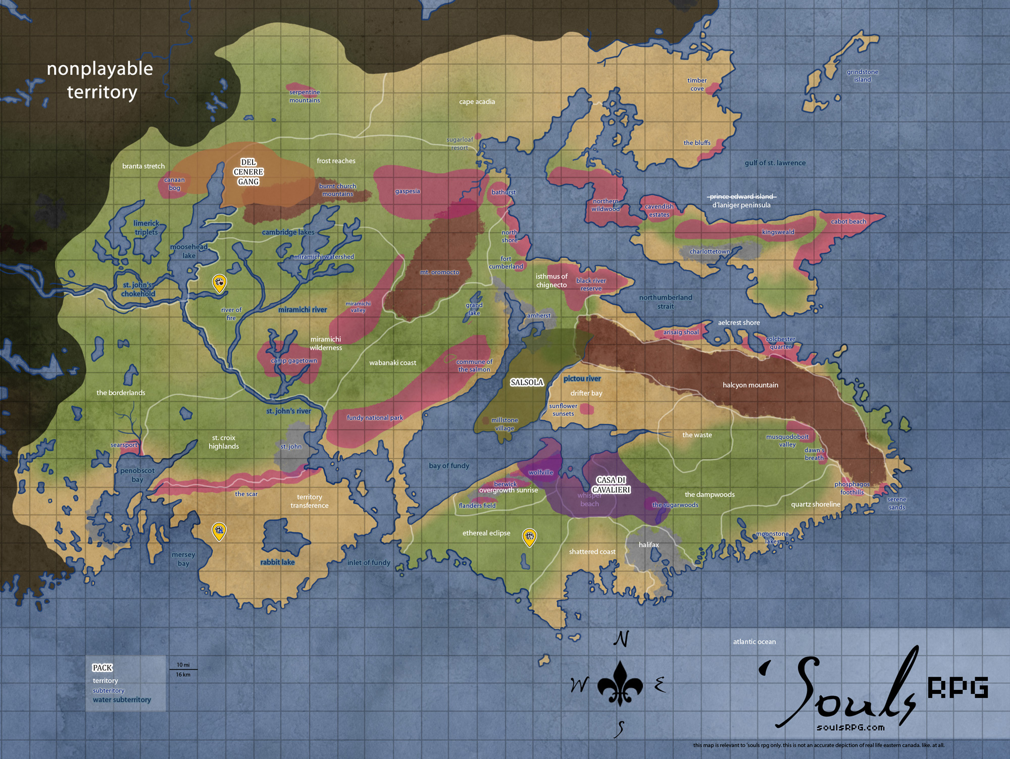
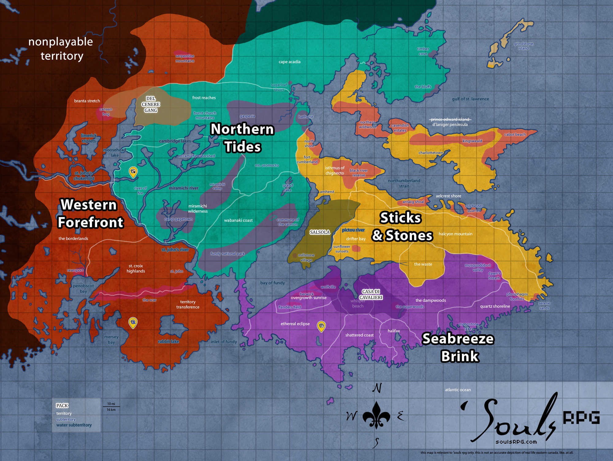
| Region | Sticks and Stones |
| Subterritories | Sunflower Sunsets |
| Major Waterways | Chignecto Bay |
| Size | 331.5 sq km / 128 sq mi |
|
Roleplay! | |
1. Description
While boasting some of the highest tides in its bay, this area is known more for its shores then anything else. A menagerie of shells, driftwood, rocks and minerals are often washed up onto the sandy shores. Follow any of the many bike trails further from the coast and the sand gives way to wide plains, decorated by sprawling wildflowers and thicker shrubbery as one moves north. This area also is home to several cliffs, many of which contain fossils.
2. Subterritories
2.1 Sunflower Sunsets
A good ways away from the shore rests a large patch of Sunflowers, which gives this area its name of Sunflower Sunsets. Thought to perhaps be a sunflower farm at some point, the rows of the golden flowers extend off in all directions, eventually fading off in to patches of other wildflowers. Here, if one is inclined to do so, is the best places to find birds from all over the area. Once the sunflowers bloom the Sunflower Sunsets can be found simply crawling with avian life, all who have come to feast to their heart's content.
3. Landmarks
3.1 Tantramar Marshes
The Tantramar Marshes are a major region of Nova Scotia and part of New Brunswick. The marshes were primarily used for the growth of hay during the time of the humans; the flat, open land made it perfect for that purpose. Switchgrass and Bluejoint dominate plant growth, along with scraggly Jack Pine trees. This land extends over The Waste, Drifter Bay, and part of the Isthmus of Chignecto.
3.2 Basalt Headlands
These high-rising cliffs line the northern edge of the Minas Basin in the Bay of Fundy. Basalt is a type of volcanic rock—this area was home to plenty of volcanic activity 200 million years ago, leaving behind the jagged and high cliffs that comprise the shoreline of Drifter Bay. The Basalt Headlands are among the most impressive along the entire coastline.
3.3 CFS Debert (aka The Waystation)
Canadian Forces Station Debert was "most recently used during the Cold War as a communications facility." Although functions at the station continued right up until the demise of humanity in 1988, the base was already well on its way to being decommissioned. The military complex is entirely underground, marked only by a strange-looking hill, rising out of the otherwise flat plains awkwardly. The bunker's opening is just barely large enough for a small car to haven driven through, though the downward passage promptly narrows to just a person's width.
4. Waterways
4.1 Chignecto Bay
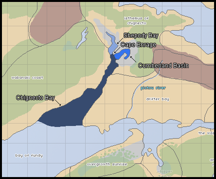
The Chignecto Bay
Chignecto Bay is long, narrow sub-basin of the Bay of Fundy. It extends far inland into the Isthmus of Chignecto area. Wabanaki Coast is to the west and Drifter Bay sits to the east. The Chignecto Bay itself has two separate sub-basins: the Cumberland Basin sits to the east, and the Shepody Bay sits to the west.
- Cumberland Basin
Although the Cumberland Bay's waters are no less dangerous than neighboring Shepody bay, the Cumberland is comparatively calmer. The shoreline is less muddy and more rocky, though copious mudflats are still found throughout the area. The area around the Cumberland Basin was more heavily populated in the time of humanity; the heart of suburban Amherst surrounds the basin. - Cape Enrage
Cape Enrage is the name given to the southern tip of the peninsula that separates the Shepody Bay and the Cumberland Basin. Cape Enrage derives its name from the large peninsula that extends south into Chignecto Bay. This causes the water off the point to become extremely violent, particularly at half tide when more rocks are exposed and the water is moving quickly. - Shepody Bay
Shepody Bay extends far inland. It consists of 77 km2 of open water and 40 km2 of mudflats, with 4 km² of saline marsh on the west. Eroding sand and gravel beaches covering an area of approximately 1 km2 on the eastern shore. A huge number of Shorebirds and other coastal life can be found all along the Shepody Bay. The bay and much of the immediate surrounding coast was designated as a bird preserve and protected wilderness prior to the demise of humanity. Beyond the preserve, the ruins of Amherst's rural outskirts, primarily former farming and fishing villages, huddle against the tide and wind.
4.2 Minas Basin
The Minas Basin is the easternmost area of the Bay of Fundy. Drifter Bay sits to the north, with The Dampwoods and Whisper Beach to the south. The Minas Basin is defined by the huge headland area in Whisper Beach, known as Cape Split; a narrow channel, known as the Minas Channel, separates the Minas Basin from the rest of the Bay of Fundy.
Sediments in the basin, which are brought in and deposited by tides, range from coarse sand to fine silt and clay -- and contribute to the thick, brown color of the waters. No other coastal marine area has such a large proportion of its floor exposed at low tide. This results in large mudflats at low tide, consisting of thick, sinking bay mud (thick deposits of soft, unconsolidated silty clay, which is saturated with water -- often running) that can easily trap a canine, horse, or other heavy creature.
- Minas Channel
Though one can view the opposite shore from Cape Split on a clear day, the extreme volume of water flowing through the narrow point of the deep, 5-kilometre (3.1 mi) -wide channel Minas Channel makes for incredibly dangerous tides. At mid-tide, the currents exceed 8 knots (4-metre (13 ft) per second). The flow on the north side of Cape Split equals the combined flow of all the rivers and streams on Earth together (about 4-cubic-kilometre (0.96 cu mi) per hour.). - Southern Bight
The southerly area of the Minas Basin, the Southern Bight, has Overgrowth Sunrise to the west and Whisper Beach to the east. The Southern Bight is 59% estuary mudflats, 34% marine flatlands, 7% salt marsh, and less than 1% sandy beach. - Cobequid Bay
The small, narrow piece of the larger Minas Basin that extends into The Waste. The Cobequid Bay, similar to the Shepody Bay in the Chignecto Bay, receives the brunt of the Bay of Fundy's tides. The coastlines are sharp, stark headlands that rise over mudflats -- or just barely contain the baywaters, depending on the tide.
4.3 Newville Lake (Salsola)
This glacial lake is located in the northern part of Drifter Bay. Newville Lake nestles into a low and rolling hill, almost perfectly rounded yet created by nature and not man. At one point in time, the humans living in the Millstone Village area used this as a water supply; a rugged and ill-kept path leads from the village to this lake.
4.4 Pictou River
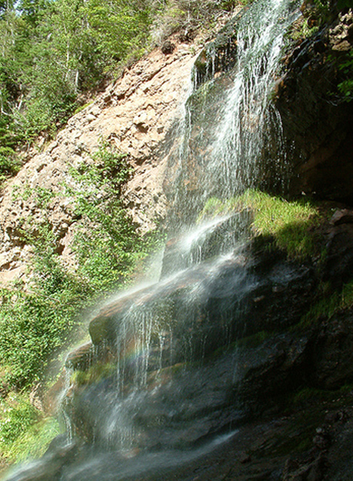
The Pictou River runs over Halcyon Mountain. Cold and fresh water springs forth from somewhere deep within the mountain. During the course of its downstream travel, the river meets a sharp cliff face; it falls well over thirty feet into a deep pool below. The river continues downstream before doing the very same thing over again. This pattern repeats four times down the stretch of the mountain, with rolling and rocky cliffs on either side of the waterfall the whole way down. The lowest waterfall is the only one that is safe to jump, as the drop is a mere ten feet and the pool at the bottom is the largest, but the rest are no less picturesque for their danger.
The Pictou River cuts a swift course between the Isthmus of Chignecto and Drifter Bay, separating the two territories as it travels southward to empty into the Bay of Fundy in the Minas Channel. Due to its location, the lower parts of the river experience a severe tidal bore. The water rushes against the current for a good distance up the Pictou; the lowermost parts of the river are heavily salted and close to brackish for much of the day.
4.5 Parrsboro Harbour (aka Sal Palus)
Nestled close to the center of the Drifter Bay territory. It is a wide-mouthed bay, with only a gentle inward curve of land to suggest a bay. Like much of the coast of the Bay of Fundy, Parrsboro Harbour is subject to the extreme tides found throughout the area. However, it is unique in that the habour almost completely empties on low tide. One is ill-advised to travel too deep into the muck: it is very deep and very easy to get trapped, which can, of course, be fatal with an incoming tide.
5. Islands
5.1 Five Islands
These five tiny islands sit just off the coast of The Waste on the Bay of Fundy. All of the islands support a number of Seal species.
- Moose
Early in the 1800s a man settled here with his family. He cleared the forest and established a modest mixed farm. Rumors circulated about his abusive tendencies; he died under violent, suspicious circumstances and the remainder of his family moved to mainland Canada, abandoning the island. Legends continued to circulate about the island in the times of humanity; it's said sometimes a light can be seen on the beach of Moose island. - Long
The sea, being in the Bay of Fundy's tide reach, is 30 to 50 feet (9 to 20 m) deep at high tide and empty at low tide, so access to the island is limited each day to a four hour window, namely the high tide during daylight. When the tide is low, those on Long Island can walk or run on the sea bed for miles. The largest island, Long has a tiny "town" of three dilapidated shacks. - Diamond, Egg, Pinnacle
These smaller islands were not inhabited. The larger of the pair -- Diamond and Egg -- sparse, piney forest and birds. Pinnacle, on the other hand, is little more than a bare rock jutting from the bay.
6. Likely Encounters
- Bay Horses
- Salsola members frequent the northwestern areas frequently, and are often found tracking the Bay Horses.
7. History
- Salsola and Inferni once maintained the Bay Horse population together with an annual round-up and branding.
8. Sources