
Western Forefront
|
Areas Page Editors: please follow the Guidelines, whether you are editing an in-game area or World Territory. |
 | |
|
Territories | |
|
Roleplay! | |
IntroductionOn this page... (hide)
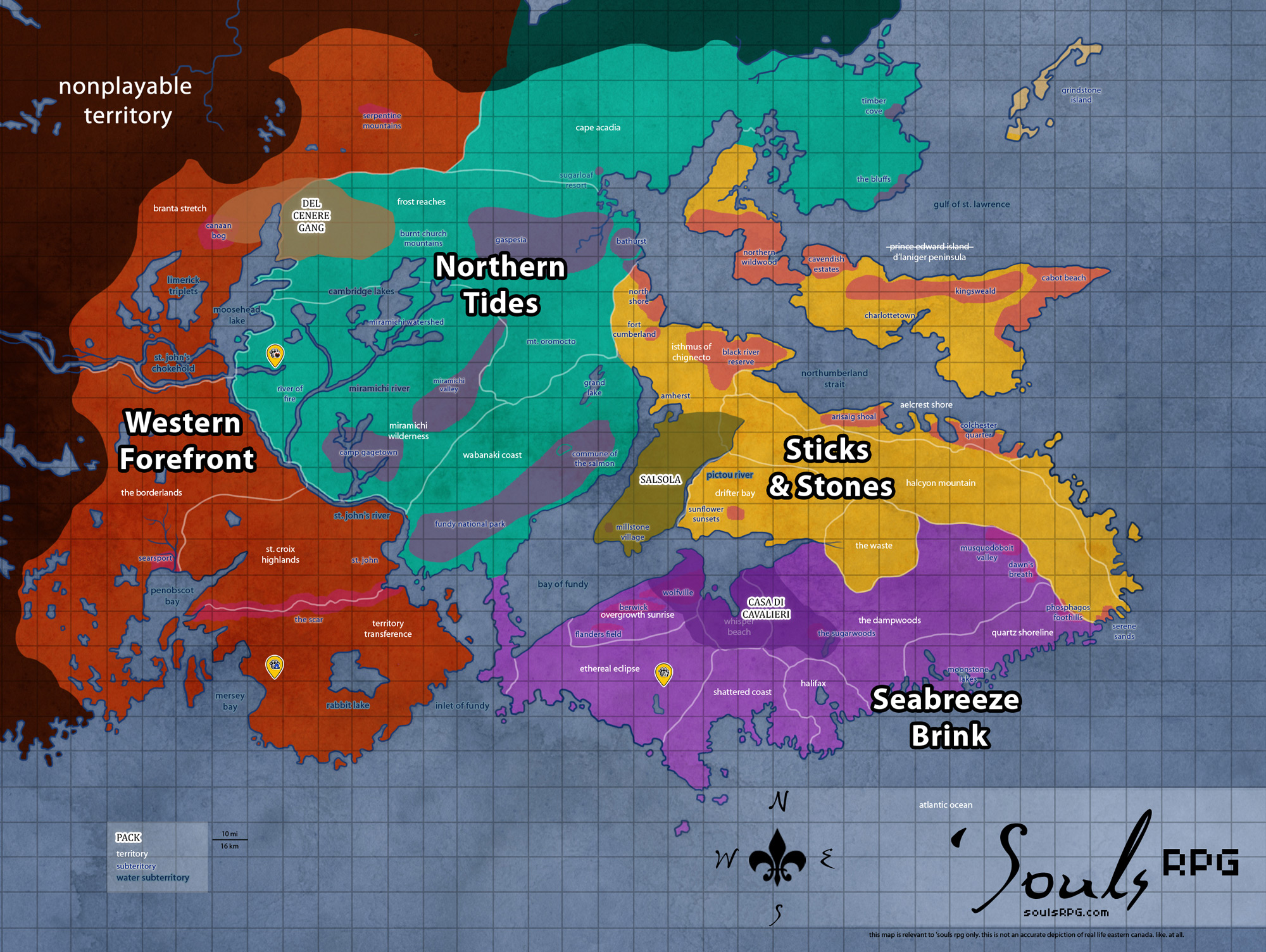
The Western Forefront territories comprise portions of New Brunswick on mainland Canada. The southernmost territories of the Borderlands include the mountainous St. Croix Highlands and the Atlantic coast city Saint John. Penobscot Bay and the Freetown are located to the southwest. St. John's chokehold separates the Borderlands from Branta Stretch, where the Canaan Bog meets the tundra like Serpentine Mountains. During November-December 2022, a series of quakes mysteriously detach the western end of the Nova Scotian peninsula and connected it instead to the mainland. The affected piece of the former-peninsula became known as the Territory Transference. The incident battered Saint John and destroyed the remainder of Freetown.
1. ClimateThe lowlands feature long, dry summers that often spark forest fires, with the exception of the stretches of marshlands that seem to be humid and mysteriously foggy most of the year. The climate turns harsh and colder along the steppes like area of Serpentine Mountains, and the weather is often cloudy and wet, with harsh winds. The climate changes along the northern mountains, becoming drier and colder with the rising altitude. The mountains are covered by deep snow most of the winters, and the snowcaps don't disappear until early summer.
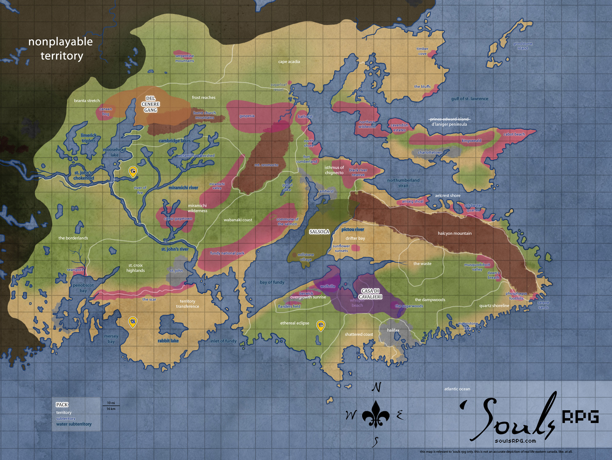
2. GeographyThis region is diverse in geography, and the areas vary from flat and dry lowlands and wet bogs to flat mesa-like territories with more genuine mountainous space towards the north. The area is significantly less arboraceous than other regions.
3. DemographicsThe Saint Croix Highlands with the Atlantic coast city of Saint John were the most populated areas before the apocalypse. Freetown was a significant hotspot for luperci until the meteorite hit in 2015, and has since lost its status as the prominent trade port west for Nova Scotia. Although there are human evidence elsewhere in the drier parts of the lowlands, most areas are completely claimed by nature, with the exception of scattered rural villages along the northern parts where the area becomes more mountainous. |
4. Common Flora & Fauna
5. Waterways
Saint Croix Highlands
Saint John River

Saint John river
This huge river trails across the easternmost section the Western Forefront territories, creating the border between this region and its neighbor, the Northern Tides. Saint John River is fed by a large number of smaller rivers, streams, and creeks -- even the larger Miramichi contributes to its outflow. In the lower sections in the broad floodplain around Saint John, flooding may occur during late spring from the sheer volume of water which must make its way through the narrow gorge at the Reversing Falls.

Reversing Falls currents
Reversing Falls
The tidal inflow in the Bay of Fundy forces the flow of water in the Saint John river against the downstream river current. In the spring freshet, however, the Bay's tides are frequently overpowered by the downstream volume of water -- thus, the "reversing" of the Reversing Falls does not always occur. The rapids, or "falls", are created by a series of underwater ledges which roil the water in either direction. These rocks are a significant navigation hazard, despite the depth of water.
Branta Stretch
Saint John's Chokehold
Unique in its appearance, Saint John's Chokehold is the result of a meander or an anabranch forming two small river islands before reconnecting with the main stem of the Saint John River. The islands themselves are sparsely forested, with vegetation and thickets of trees capable of surviving the flooding that this area frequently endures. The watercourse at Saint John's Chokehold is generally tranquil, and allows for decent fishing, though this can change quickly during the spring melt and periods of heavy rain.
Limerick Triplets
As the name suggests, Limerick Triplets is a trio of small lakes situated to the north of Saint John's Chokehold. Sitting in the low-lying plains of Branta Stretch, the land surrounding the lakes is relatively marshy and soft. This provides an abundance of diversity in the types of plants and animals that can be found in this area.
Moosehead Lake
Moosehead Lake is the largest and most prominent body of water located in Branta Stretch. Stretching nearly 50 miles (80.4 kilometers) north from Saint John's Chokehold, Moosehead Lake (along with the Saint John River to the south) marks the border between the Western Forefront and the Northern Tides. It is a clear and peaceful lake, with a plentiful population of fish for those inclined to hunt its waters. In the southeastern quadrant of Moosehead Lake sits a small, round island called River Dog Island for the family of otters that can be found there.
6. Islands
7. Defunct Subterritories