
Quartz Shoreline
|
Areas Page Editors: please follow the Guidelines, whether you are editing an in-game area or World Territory. |
On this page... (hide)
- 1. Description
- 2. Subterritories
- 2.1 Moonstone Lakes
- 3. Landmarks
- 3.1 Saunder's Mill
- 3.2 Graveshill
- 3.3 Firefly Fields
- 3.4 Raven Beacon
- 4. Waterways
- 4.1 Quartz Shoreline Bays
- 4.2 Jack's Cove
- 5. Islands
- 5.1 Watcher's Rest
- 5.2 Quartz Barrier Islands
- 6. History
- 6.1 Claimed Land
 | |
| Credit | shezamm@Flickr |
|
General | |
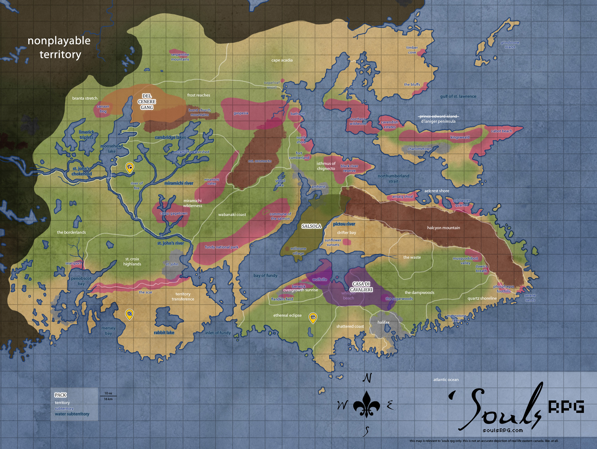
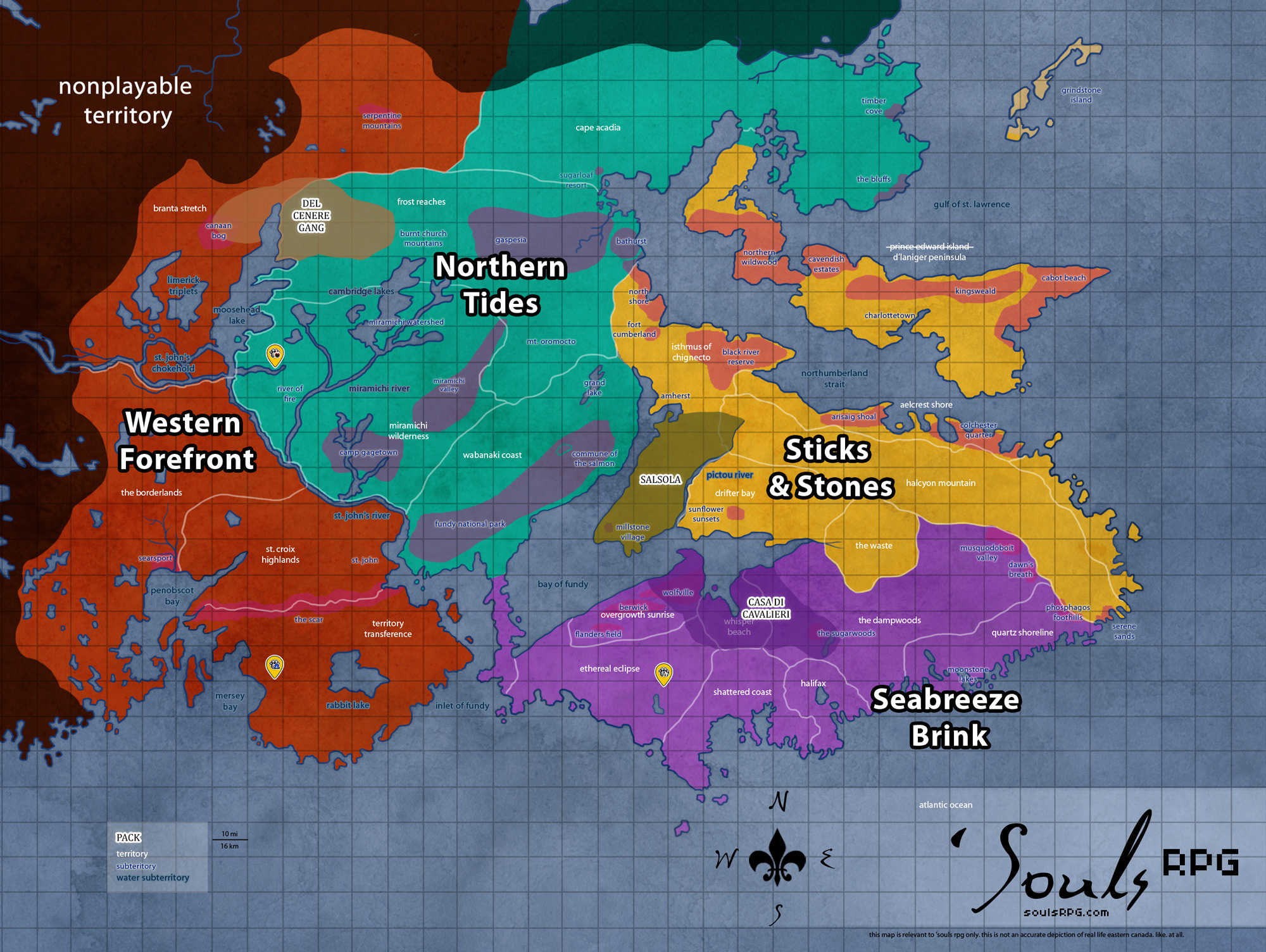
| Region | Seabreeze Brink |
| Subterritories | Moonstone Lakes |
| Major Waterways | Atlantic Ocean |
| Size | ?? sq km / ?? sq mi |
|
Roleplay! | |
1. Description
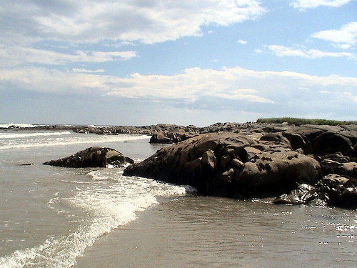
The open plains and lowland hollows of The Dampwoods to the north here turn sandy as one nears the shoreline. Smooth, sandy beaches and hundreds of tiny bays, coves, and inlets dot the shoreline here. Rocky outcroppings jot the shore here everywhere, sometimes leading out into the ocean. Hugging the shore, dozens of small barrier islands protect this coast from the ravages of the deep, cold Atlantic. Some of these islands even boast enough ground to grow sea-toughened fauna, and generally host a number of shorebirds. The western border of the territory, butting up against The Dampwoods area, has sparse vegetation and the beginnings of southerly Halifax's rural sprawl.
2. Subterritories
2.1 Moonstone Lakes
Nestled in the southern end of the Quartz Shoreline territory are a cluster of lakes, their size ranging from puddle to vast expanse. Rivers and streams snake between the various bodies of water, feeding into one another and eventually emptying into the Atlantic Ocean. On a few of the larger lakes, tiny rural communities slowly decay into the encroaching forests; some are little more than stone foundations and piles of wood. Overgrown dirt roads connect these tiny villages to larger asphalt roadways, though even these are cracking and wearing under the pressure of decades.
3. Landmarks
3.1 Saunder's Mill
This area was more of a historical site than anything else during the time of humanity. The mill building still stands, though it was not productively used for many years even before the apocalypse, aside from demonstrations and reenactments. The thin river that runs alongside the mill pours into the Mirror Lakes. This river once powered the mill, and though the paddles still stand in the waters, they have been silent and motionless for many years now.
3.2 Graveshill
This small graveyard nestles to the east of the smallest Moonstone Lake. The cemetery itself is small, housing only a few dozen headstones. Nevertheless, the air always seems a tad bit chillier than it should -- though some would say that is only due to the shallow bowl where the cemetery sits, a lowlands area with soft soil in the otherwise rocky, Erratic-strewn Quartz Shoreline. Still -- the grass is sickly-pale, as if the buried human dead choke away life with their presence. Explorers will find no flowers in this graveyard -- only the pale grasses, thin and balding in patches where the lumpy graves make the earth misshapen.
3.3 Firefly Fields
The only remnants of man within the fields are an old shack and the rusty leftovers of a wagon beside it, decayed well beyond use. In spring and summer, the field is a sea of green grass as tall as a werewolf's knees in summer, dotted with patches of thick wildflower growth. Lofty Red Pine trees litter the stretch, though scattered or in tiny stands of two or three. These tall trees make for excellent shade from the sun that hits the field from sunrise to sunset.
3.4 Raven Beacon
This old lighthouse sits on the farthest point of the Quartz Shoreline area, reaching into the cold Atlantic Ocean. An old, gas powered beacon lighthouse once lit the way for ships, but it has long since ceased operation. The stone structure is strong, however, and a near twin to the one found on the tiny island of Watcher's Rest.
4. Waterways
4.1 Quartz Shoreline Bays
All of the Quartz Shoreline is bay, harbor, inlet, and estuary. Unlike its southerly counterpart the Shattered Coast, this territory does not have especially large bay areas. Instead, the Quartz Shoreline has an incredible myriad of innumerable small bays, few of which have names. Ranging from stony and jagged to smooth and sandy, there is an incredible variety of beaches, salt marshlands, coves, and river outlets along this coast.
- Musquodoboit Harbour
Musquodoboit Harbour is a 10 km long estuary measuring about 2 km wide at its southern end (the mouth) and narrowing to less than 100 m wide at the northern end where the Musquodoboit River discharges into the harbour. The beach here is the longest sandy beach in Nova Scotia. This 5 kilometre long beach was a provincial park and wildlife area in the time of humanity. shorebirds can often be seen during migratory periods. - Hawbolt Cove
Hawbolt Cove sits to the south of Musquodoboit Harbour, housing the Quartz Barrier Islands of Hemloe, Liscomb, Goose, Barren, and Crooks. Notable for its populations of Shorebirds, Seals, and other coastal life, Hawbolt Cove is an attractive place for Luperci hunters as well as those simply seeking a beautiful beach and accompanying salt marsh. - Smoke Point
Smoke Point sits quite near to Halifax. With a large, jutting peninsula stretching between two smaller bays on either side, those near the endpoint of land on the peninsula are afforded a view of Halifax -- on clear days. The area is well-named, for the area is typically home to thick, low-lying fogs. Nevertheless, on sunny days, the view is breathtaking and well-worth the sight.
4.2 Jack's Cove
Along the coastline of the Quartz Shoreline is an area where the ocean seems more lively than most. As the ocean waters recess with the tide, small pockets of seawater remain along the edge of the rockier portions of Jack's Cove's beach. These pools teem with marine organisms of all sorts, from crabs and fishes and clams to barnacles and urchins. Luperci seeking an easy meal would do well to visit the tiny cove, though adults and puppies alike can enjoy splashing through the pools. They range in shallowness from no higher than the toes to deeper than the chest, depending on the depth and composition of the rocks and sand beach.
5. Islands
5.1 Watcher's Rest
Hunkering near near the beginnings of the Halcyon Mountains, the shoreline boasts a large island. The isle is rocky and windswept, home only to a handful of hardy Shorebirds. An ancient lighthouse still stands sentinel over the harbour, warning those who would come too close to the shore about the underground peaks and hidden sea rocks. The stone building is discoloured and has been thoroughly battered by the elements.The structure's stairs are treacherous, but the view of the Atlantic Ocean from the top is stunning.
5.2 Quartz Barrier Islands
The Quartz Shoreline boasts a large number of small islands along its shore, most of them barrier islands with little more than a few rocky spires jutting from the sea. Some of the largest, however, support vegetation and bird life. Most of these islands are easily accesible from the shoreline -- either by following along other barrier islands, or by simply swimming out to sea. The Atlantic tides are far more forgiving than the Bay of Fundy's tides; one need only watch for riptides and oceanic currents.
- Northern Barrier Islands (Hemloe, Liscomb, Goose, Barren)
The Trinity Islands are composed of three bare, sparse plateaus jutting from the ocean. Though once dotted with small summer cottages, most of these former human dwellings have fallen to sand and shore. By contrast, the largest island of Hemloe contains a limestone mansion atop a hill. Though it has decayed due to the battery of wind, rain, and salt, the strong structure remains standing. A wild, overgrown garden surrounds the mansion and dominates Hemloe Island. Barren Island, south of Hemloe and a distance from the trio, supports a small rabbit population, as well as a large amount of vegetation. The rabbits might have taken over the island, but cats, hawks, and eagles keep their numbers at bay. All of the Northern Barrier Islands sit outside of the Hawbolt Cove area, protecting it from the Atlantic Ocean. - Crooks Island
Crooks Island sits to the east of Barren Island, far outside the group of four barrier islands. Among the most seaward of the barrier islands, Crooks Island supports no mammalian wildlife. Only shorebirds and the occasional mainland bird are seen on this rocky outcropping. A small stand of pine trees conceals a shallow cave network. Seawater fills some chambers of the cave at all times, but others are completely dry, providing small shelter. During the time of humanity, it was rumored pirates used the island for a hideout.
6. History
6.1 Claimed Land
- The landmarks Saunder's Mill, Eagle Tower, Hill of Graves, Firefly Fields, and Jack's Cove -- were claimed by Phoenix Valley from 2008 to 2011.
- The landmark of Watcher's Rest was previously claimed by Anathema from approximately 2010 until its disbandment in 2018.