
Northern Tides
|
Areas Page Editors: please follow the Guidelines, whether you are editing an in-game area or World Territory. |
 | |
|
Territories | |
|
Roleplay! | |
IntroductionOn this page... (hide)
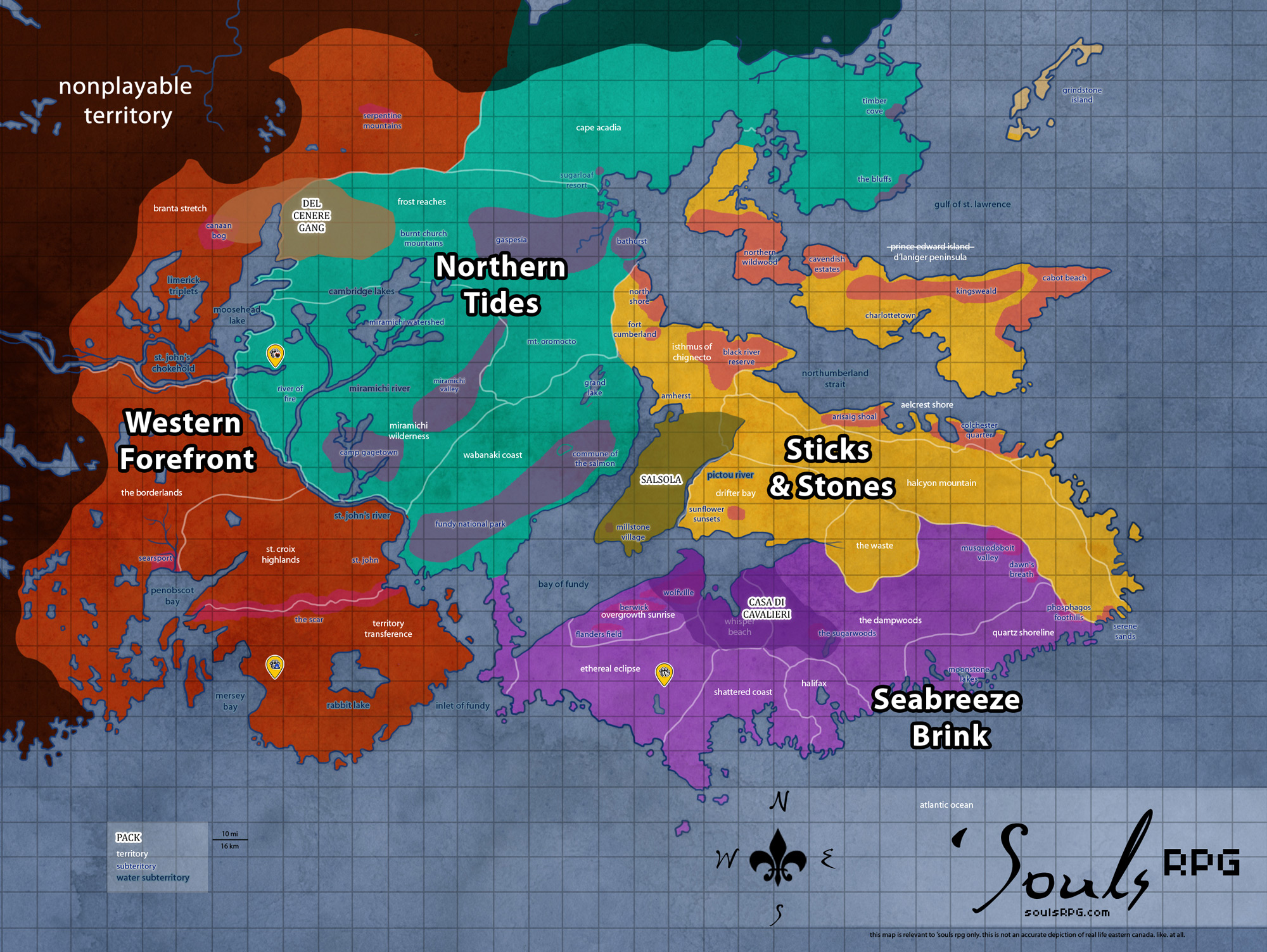
The Northern Tides territories consist of mainland Canada west of the Isthmus of Chignecto, the land bridge connecting the peninsula to the mainland. The easternmost territories of New Brunswick are included in the Northern Tides region. Although it is a trek for many canines of the peninsula to come to this area, more and more have been traveling to Freetown and other parts unknown for trading and other purposes.
1. ClimateAlthough the climate of New Brunswick is maritime and not extremely dissimilar to Nova Scotia, it is more akin to ocean-sheltered mainland Canada. Winters are longer and colder, frequently accumulating more snow than the peninsula regions. Although the Northern Tides region experiences its share of foggy days, the skies are generally clearer on this side of the bay.
2. GeographyThe Northern Tides region is rather mountainous, possessing various peaks of typical Appalachian size. Glacial valleys are commonplace, such as the Miramichi Valley. Lush forests nestle within these valleys, with numerous rivers, lakes, and other waterways scattered throughout the region. The coast here is dominated by the Bay of Fundy and its extreme tides; unique features such as raised beaches and sea stacks, such as within Cape Hopewell, are commonplace.
3. DemographicsThe southern third of New Brunswick was the most populous before the apocalypse. The settlement patterns and the economy of New Brunswick are based more on the province's river systems than its seacoasts. Much of the human evidence elsewhere has faded with time; small villages hunker in vast forests. Most north-central farmland has already lost its battle with the wild overgrowth; the land almost appears untouched by humanity. |
4. Common Flora & Fauna
4.1 FloraUnderbrush
Trees
|
4.2 FaunaAbundant, with the exception of the hilliest and roughest terrain of high altitude, particularly north of Mount Oromocto. Many creatures found in this area are similar to those found on Nova Scotia.
|
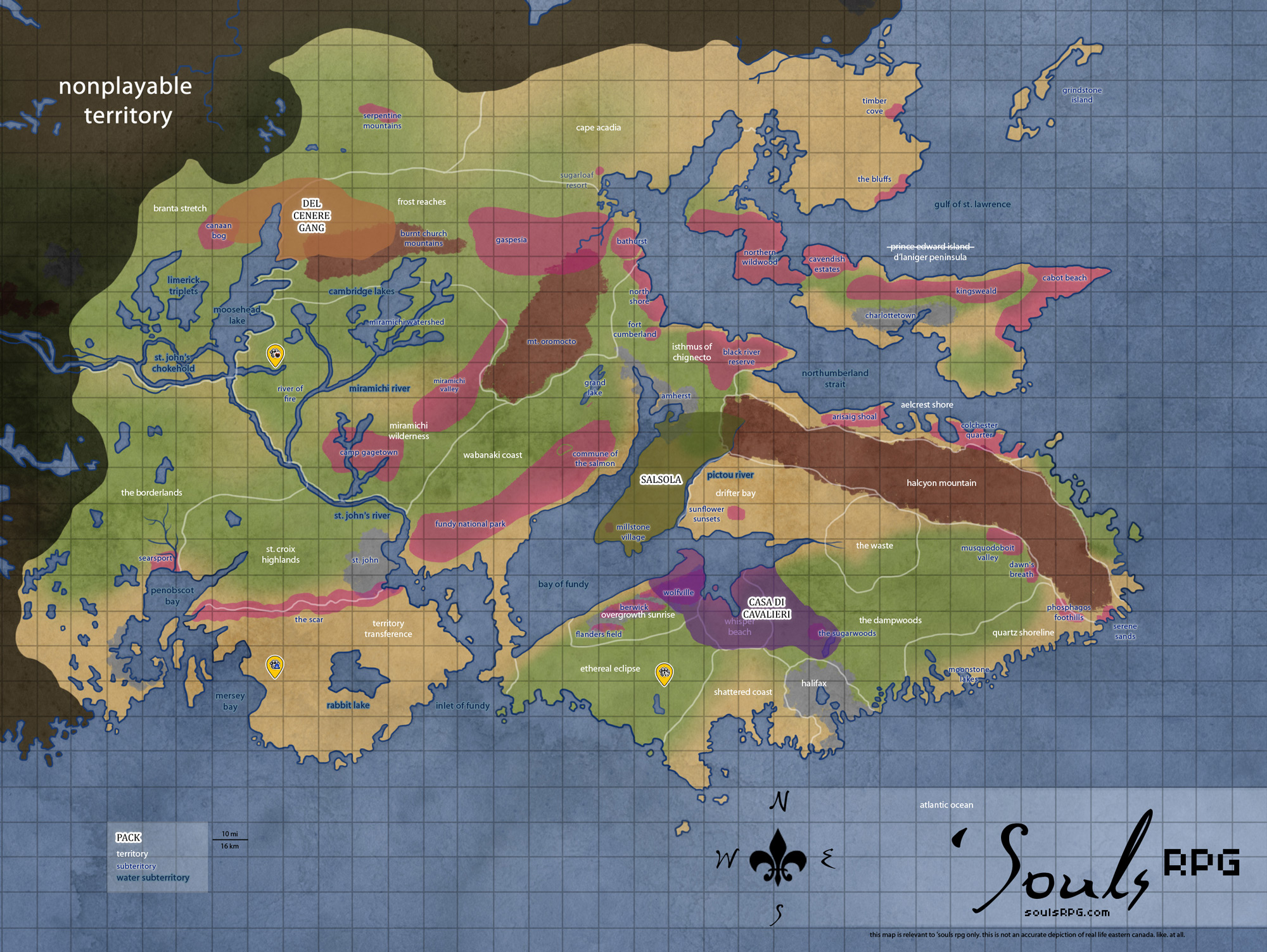
5. Waterways
Wabanaki Coast
Grand Lake
Grand Lake is the largest lake in the Northern Tides region. Its shores are dotted with the remnants of small villages of beach cottages, many of which depended on the fishing economy in the lake for sustenance. The northern shore is barren and bare, razed of trees during the time of humanity. Explanation for the peculiar baldness of the north coast lies with the sawmill also present on the same shore. Much of the machinery is damaged beyond repair, and many smaller outbuildings of the sawmill complex have completely collapsed.
Miramichi Watershed
Miramichi River
The Miramichi River refers to a collection of rivers: there are Little and Big Miramichi Rivers, as well as the Northwest Miramichi and Southeast Miramichi. Many tributaries are in the Miramichi Watershed areas, but several streams and one Miramichi River (perhaps the Southeast or the Little Eastern -- no one is quite sure) cuts through the Miramichi Valley. The thickest part of the river takes a turn into the flatlants of the River of Fire and finally meanders south to the larger Saint John River. It is a meandering river, with very slow-moving waters. Much of its downstream waters are muddied, thickened with the silt and sediment picked up throughout its vast headwaters.
Bartibog River
The Bartibog River is a tributary of the Miramichi River, rising in the northeast of the Miramichi Watershed. It flows east and south into the Miramichi. Where the two rivers meet, a small community (also bearing the name Bartibog) nestles on the peninsula behind the rivers' meeting point. The town poorly situated -- since the time of humanity, at least half of it has sunk back into the mud. Half-drowned houses stand nearest to the meeting point of the Miramichi and the Bartibog, though the northern half of the town is still dry as of yet. Outside of this community, the Bartibog River watershed is entirely rural, dominated by forests and small farms.
- Moody's Point
The promontory on the east bank of the Bartibog River, across from the town of Bartibog proper, is called Moody's Point. It is the location of one of the oldest Roman Catholic Churches in the area, dating from the 1850s. The stone church is well-situated to avoid flooding, though its stones are damp and its air is generally humid.
6. Islands
6.1 Saint John
Bone Island
Bone Island is a small island near the mouth of the Saint John River. The 6.5 acre (26,000 sq feet / 13277 sq meters) island is located approximately 4 mi (6 km) from the mouth of the river. Despite its rocky and foreboding coasts, it is a landmark -- especially for canines heading by sea to The Outpost for trade. Bone Island gained its name from the large number of bones found on the island -- primarily human bones -- during the time of humanity. Any remaining bones long predate the demise of humanity -- Bone Island was not occupied by any humans in 1988.
Estates Island
Estates Island, located in the midst of the Saint John river, was used as summer estates in the time of humanity. The island contains many secluded beaches along its perimeter and has a natural deep-water cove. During the spring melt, high waters often pinch the island into two entirely separate entities near its thinnest point. During the winter, however, it is possible to walk across the ice cover of the bay to the island.
6.2 Machias Island
Machias Island is a small, rocky island near the southern point of Wabanaki Coast. It is fog-bound for many days of the year, but can be seen clearly from the shore on clear days. Despite its size and relatively sparse amount of vegetation, Machias Island supports a large population of Shorebirds and Seal. It is therefore attractive to Luperci seeking some easy prey. The tides of the Bay of Fundy make it a dangerous excursion, but the number of lazy, sprawling seals makes for a temptation anyway.
6.3 Northumberland Islands
Heron Island
Heron Island is a large island off the north coast of the Aelcrest Shore in the Northumberland Strait. It is quite close to Arisaig Shoal's biggest bay. The island is accessible only at high tide from a wharf on the south side of the island; rocky and foreboding cliffs make approach impossible otherwise. There is a human native traditional burial ground near the northwest end of the island. Large enough to support a thick swathe of tall trees, Heron Island's proximity to land and appearance make it a tempting target for explorative Luperci. The currents in the Northumberland Strait, too, make crossing to Heron Island an easier journey than one of the Fundy islands.
Miscou Island
Even larger is lush Miscou Island, located just above the peninsula extending above Fort Cumberland. Miscou island is quite large, having supported a community of about 650 humans before the apocalypse. The French-speaking community was accessible only by cable ferry (which no longer exists). There are barrier islands extending to the southeastern corner, but there are breaks between the islands and one needs to swim in order to access the thickly-forested island.
The major industry was fishing, primarily lobster and herring. Peat moss on the island has not been harvested and is left in its natural state. The island's sand dunes and lagoons host a variety of migratory birds, and its gentle shorelines invite mainland Luperci into the cold waters of the Northumberland Strait.
7. Parks, Reserves, Etc.
8. Image Gallery
 Saint John High School |
 Stone Church |
 Saint John Regional Hospital |
 Wiggin's Orphan Asylum |
9. Sources