
Saint John
|
Areas Page Editors: please follow the Guidelines, whether you are editing an in-game area or World Territory. |
On this page... (hide)
- 1. Description
- 2. Landmarks
- 2.1 Neighborhoods
- 2.2 The Outpost
- 3. Waterways
- 3.1 Saint John River
- 4. Islands
- 4.1 Bone Island
- 4.2 Estates Island
- 5. Parks, Reserves, and Natural Areas
- 5.1 Rockwood Park
- 6. Image Gallery
- 7. Likely Encounters
- 8. History
- 9. Sources
 | |
| Credit | slworking@flickr |
|
General | |
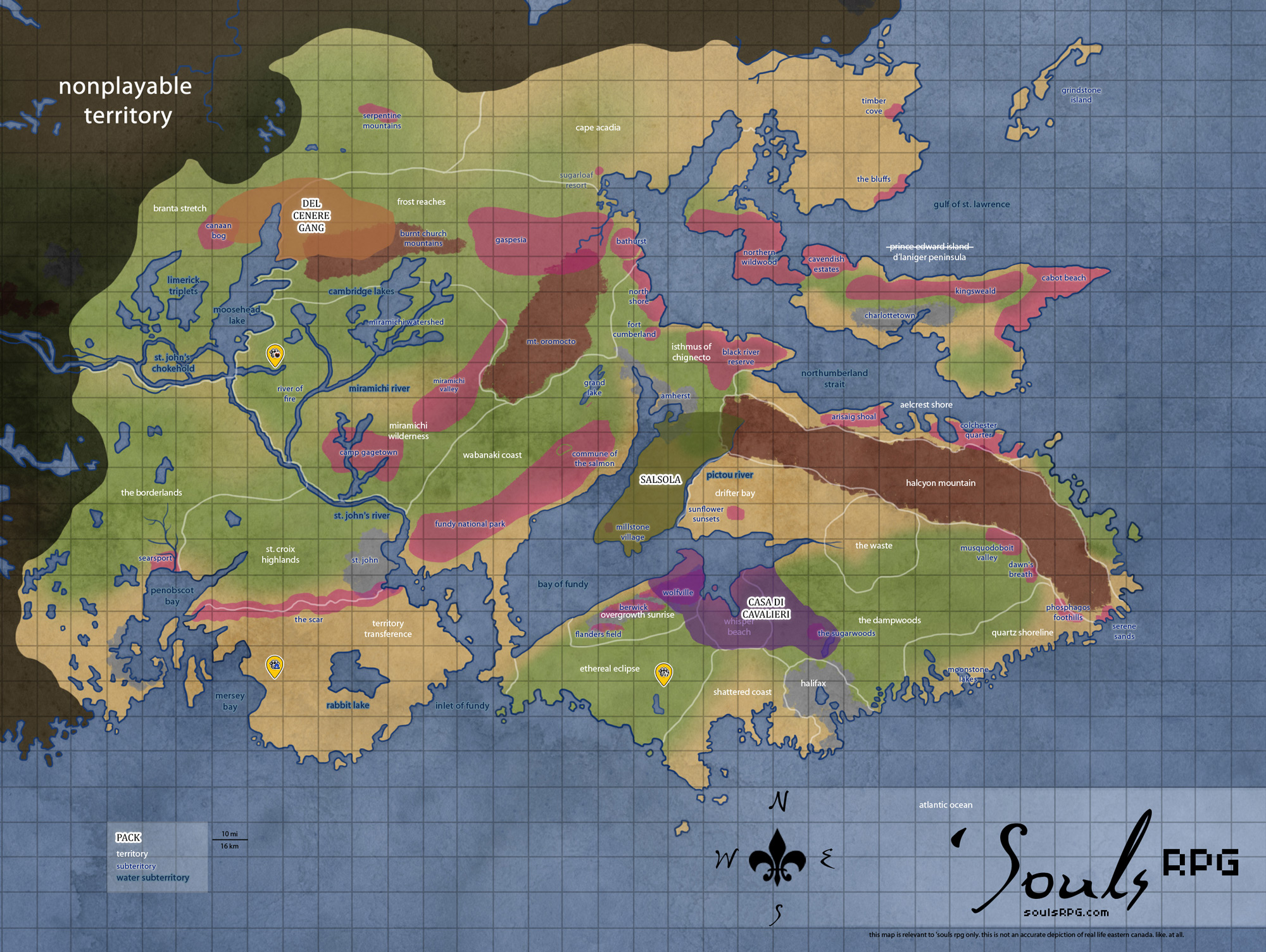
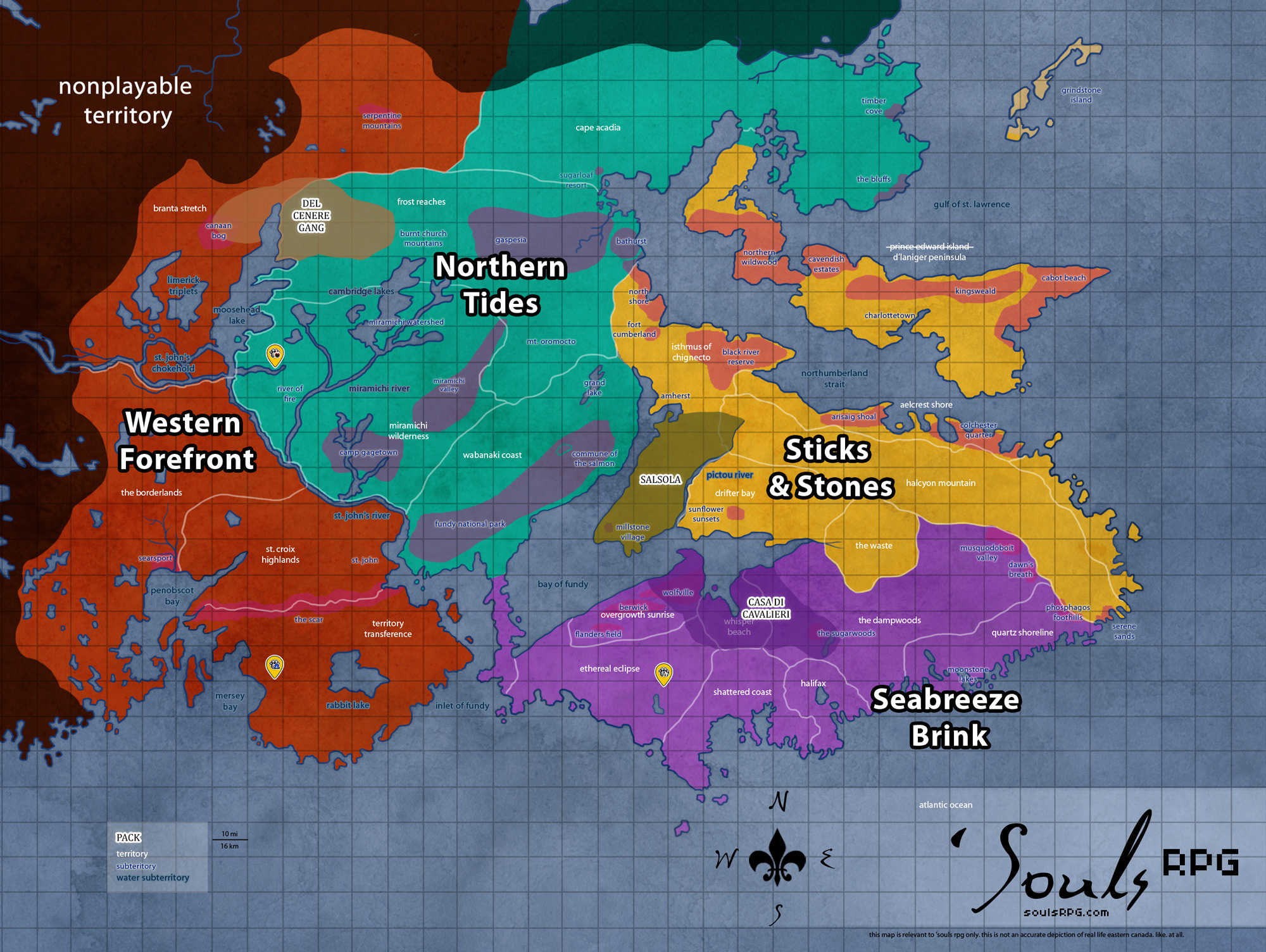
| Region | Western Forefront |
| Territory | Saint Croix Highlands |
| Major Waterways | Bay of Fundy |
| Size | 422 sq km / 200 sq mi (Metro) 132 sq km / 82 sq mi (Urban) |
| Note | Packs cannot claim this area. |
|
Former Human Occupancy | |
| Population | 127,800 (Metro) 96,000 (Urban) |
| Dwellings | 33,500 |
|
Roleplay! | |
1. Description
Although Halifax is larger than Saint John, this coastal city is as impressive, boasting tall buildings and a once-bustling metropolis. Like the Nova Scotian city, Saint John is also situated on a harbor. Many buildings closest to the shoreline are in the worst disrepair; a few have fallen into the harbor entirely. Inland construction is more secure, but all show wear and signs of nature's march forward.
Four distinctive neighborhoods form Saint John city: residential, retail (Central, East, West), commercial (East, West), and working class (East, South). In general, Saint John is in worse shape than Halifax, primarily due to the colder and harsher climate of mainland Canada. Still, many of the brick and stone buildings still stand tall, built strong to last long.
Saint John has a low level of both flora and fauna. Though plants and trees have begun to overtake parts of the city, it is certainly not thick, untouched wilderness. Some parks do support small populations of Deer and sometimes even larger ungulates; Rodents and small mammals, as well as birds, are plentiful. Nonetheless, Saint John lacks enough prey to support a Luperci pack.
2. Landmarks
2.1 Neighborhoods
City Central
Protected by a vast array of brick buildings and stone churches, the central part of the city is home to a variety of stunning landmarks, most notable of this is the Loyalist Burial Ground and King's Square. The two were build a stree apart, next to the Courthouse. In the center of King's Square is a band stand, constructed of steel and now rusted with age. Spreading from this bandstand, the paths in the square are placed to form a Union Jack when seen from above. Both the Square and the Burial Ground are overtaken with huge oak trees and maple trees, centuries old and surrounded by their saplings. The Courthouse, made of stone and sandstone, somehow still stands, while the old brick buildings around it have suffered to the point of collapse.
On the other end of King's Square is what remains of the Market. Built entirely of steel with a brick floor, all but the roof remains standing. Old Butcher Shops and Produce Stalls still line its hall, now strewn about and worn from time and salted weather.
Up the street from the Market stands the Stone Church. It bears no other name but this suites it fine, as the entire structure stands tall and proud, its one bell tower guarded by weather-worn gargoyles. The yard of the church has since become overgrown and vines cover it on all sides. The back of the church overlooks the North End of the city and has collapsed slightly. The tower and chapel still stand tall and strong, built to last. Around it, residential buildings have fallen and been covered with plantlife. In the summer, it hides the lower part of the church in green shrubs and short trees.
North End
The North End is comprised predominantly of urban residential housing. The houses here are older, built sometime in the early to mid twentieth century. Though not as busy as the City Central, there is clear evidence a large number of humans once lived here. Cars, trucks, and buses litter the streets and driveways, rotting and rusting where they stopped twenty-plus years ago. The houses are not in terrible shape, as far as houses go -- windows are generally broken open, some porches and roofs sag, and some have even collapsed. Nevertheless, the North End boasts a number of brick apartment buildings, low and long complexes with many small units tucked beside and atop one another in two or three stories at most. Some of the most prominent human ruins in this part of Saint John include a campus of the University of New Brunswick, the Saint John Regional Hospital, and Saint John's only completely French school, Samuel de Champlain.

Saint John skyline
East Side
The East Side is where the city experienced its greatest suburban sprawl, with commercial retail centres and residential subdivisions. Several somewhat distinct residential neighbourhoods as well as developments are found here. The neighborhoods were built by filling in Major's Brook (a tributary to Marsh Creek), making the area unstable. Some of the houses here are collapsing at a far greater rate than in other areas of the city -- some have been entirely demolished by time, leaving no more than a few piles of sticks and foundation stones.
The East Saint John Shopping District was one of the largest shopping/power centre district in Atlantic Canada. A mixture of finished commercial buildings, fully operational at the time of humanity's demise, and half-finished construction plots litter the area. The construction site, too, suffers the ravages of the poor human construction. A sinkhole has opened in the first floor of one of the commercial buildings, yawning wide and rather dangerous to any who do not know of its existence already.
2.2 The Outpost
The Outpost was settled on the shoreline in the southern extremes of the Fundy National Park. The Outpost was separated from the city of Saint John by the mouth of the Saint John River. A long-abandoned shoreside campsite was chosen for the spot, as it was mostly clear of old growth and overlooks the shore, providing a view of the city across the river. Low hills and thick forests surround the Outpost, though the trading post itself sits in a hollow between three these hills. The hills provide natural defense against invasion.
The first settlers of the Outpost ringed the encampment with fencing -- primarily rusted old barbed wire scavenged from the city. Over time, these defenses had been strengthened into a wooden palisade, with stakes pointing outward to ward off attackers. Though once home to several raised buildings and tents, practically all the usable wood was reclaimed as traders left. The impression of the fence is left behind, as are other signs of former inhabitance. At the center of the hollow, a raised firepit remains. Logs, stones, and other makeshift seats surround the fire ring, allowing trader Luperci to sit and share their stories. There is no grass within the area of the former Outpost except around the edges-- the ground has been trodden down to stony dirt.
In early 2016 members of The Outpost began to quietly filter their way out of the area. With trade competition growing from the permanent residents of 'Souls, many of these merchants resettled elsewhere -- first in Freetown and then further south in Portland. Some continue to visit 'Souls periodically but The Outpost is no longer the active trading post that it once was.
3. Waterways
3.1 Saint John River

Saint John river
This huge river trails across the easternmost section the Western Forefront territories, creating the border between this region and its neighbor, the Northern Tides. Saint John River is fed by a large number of smaller rivers, streams, and creeks -- even the larger Miramichi contributes to its outflow. In the lower sections in the broad floodplain around Saint John, flooding may occur during late spring from the sheer volume of water which must make its way through the narrow gorge at the Reversing Falls.

Reversing Falls currents
Reversing Falls
The tidal inflow in the Bay of Fundy forces the flow of water in the Saint John river against the downstream river current. In the spring freshet, however, the Bay's tides are frequently overpowered by the downstream volume of water -- thus, the "reversing" of the Reversing Falls does not always occur. The rapids, or "falls", are created by a series of underwater ledges which roil the water in either direction. These rocks are a significant navigation hazard, despite the depth of water.
4. Islands
4.1 Bone Island
Bone Island is a small island near the mouth of the Saint John River. The 6.5 acre (26,000 sq feet / 13277 sq meters) island is located approximately 4 mi (6 km) from the mouth of the river. Despite its rocky and foreboding coasts, it is a landmark -- especially for canines heading by sea to The Outpost for trade. Bone Island gained its name from the large number of bones found on the island -- primarily human bones -- during the time of humanity. Any remaining bones long predate the demise of humanity -- Bone Island was not occupied by any humans in 1988.
4.2 Estates Island
Estates Island, located in the midst of the Saint John river, was used as summer estates in the time of humanity. The island contains many secluded beaches along its perimeter and has a natural deep-water cove. During the spring melt, high waters often pinch the island into two entirely separate entities near its thinnest point. During the winter, however, it is possible to walk across the ice cover of the bay to the island.
5. Parks, Reserves, and Natural Areas
5.1 Rockwood Park
To the east of the city proper, the park encompasses 890 hectares of upland Acadian mixed forest, many hills and several caves, as well as several freshwater lakes, with an extensive trail network, as well as various former human attractions: the remnants of a golf park and zoo are most apparent. Rockwood Park is known for its many deep winding tunnel systems, all naturally formed from dried rivers underground. Many of these caves are hardly big enough for a human, but coyotes and wild cats often make their homes in the more shallow ones. Some of these caves are thought to have once been mineshafts, though there has never been any real proof.
Closer to Cherry Brook Zoo, there is what's left of the Rockwood Stables. The horses that were once housed here have since gotten free of the low fences and their decendants can now be found wandering the park, preferring the old Golf Park for grazing and running but often returning to the sturdy-built ruins of the barn for shelter from storms. Beside the Stables is an old, reclaimed playground, with rotted swings and a rusted jungle gym.
There are a total of nine lakes in Rockwood Park. The largest being Lily Lake, the smallest being Frying Pan Lake. The rest are Fisher Lakes (a series of small lakes, classified as one, near Lily Lake), Mayflower Lake, Long Lake, Owen Lake, Crystal Lake, Crescent Lake and Harrigan Lake. Many of these lakes connect through a series of underground streams and rivers.
6. Image Gallery
 Saint John High School |
 Stone Church |
 Saint John Regional Hospital |
 Wiggin's Orphan Asylum |
7. Likely Encounters
Saint John is well-trafficked by Luperci. Though there are not many 'Souls packs directly near the city as of 2013, aside from Vinátta and Krokar, travelers from the south often make their way through Saint John on their way north. The same goes for travelers leaving 'Souls -- sticking to the coast is a common travel pattern, and this route takes canines right through Saint John.
7.1 Current
|
7.2 Former
|
8. History
- Before disbanding in February 2016, The Outpost was a popular place for Luperci both within 'Souls and outside of it to gather and trade.
9. Sources
- Wikipedia:Saint_John,_New_Brunswick
- Wikipedia:Cherry_Brook_Zoo (Rockwood Park)
- Saint John Historical Index