
Eastern Rise (Halifax)
|
Areas Page Editors: please follow the Guidelines, whether you are editing an in-game area or World Territory. |
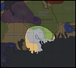
The Eastern Rise region is situated around Halifax, once the largest city in Nova Scotia. The metropolis lies in ruins among the beautiful beaches and former vacation hot spots, eerily silent without the honking of horns. The city's sprawl is an even mixture of farmland and fast-fading suburbia, interspersed with forests and wildlife preserves.
On this page... (hide)
- 1. Statistics
- 1.1 Climate
- 1.2 Geography
- 1.3 Demographics
- 2. Common Flora & Fauna
- 3. Waterways
- 4. Islands
- 5. Links
- 5.1 Forum Links
- 5.2 Offsite Links
1. Statistics
1.1 Climate
The central parts of Nova Scotia are the most moderate -- the surrounding bay and ocean do much to mitigate the harshness of Canadian weather. The summers are especially warm and beautiful, and the central regions have been spared winter's sharp bite in previous seasons.
1.2 Geography
This small Atlantic coast region is situated in a basin of low elevation. The coast is jagged and the shoreline is dotted with small islands.
1.3 Demographics
Halifax was the most populous area of the Nova Scotia and New Brunswick prior to human extinction. Many areas of this region show extensive evidence of human occupation, from the sprawling farms to the suburbs to to the metropolis.
2. Common Flora & Fauna
2.1 Flora
|
2.2 FaunaSparse. While Loners may subsist on the small creatures found in Halifax and its surrounding areas, a pack would find it impossible to survive here. Rodents and small mammal species comprise the majority of resident species; various species of bat use the buildings to roost. Golden eagles also use the buildings for their nests during summer. Small to medium sized songbirds and predatory owls are the most common fauna within Halifax. Formerly domesticated animals are frequently seen in this area -- cattle are common on the Chebucto Peninsula, but do not venture outside of the wooded and field areas.
|
3. Waterways
Primeval Memories
Vapor Lake
Yawrah River
The Yawrah River begins in the upper parts of the Acheron Peak area, fed by the Tranquil Springs. It snakes down through the mountains and flows across much of the Cape Breton Peninsula, picking up several smaller creeks and streams through its long course.
Its currents are lazy and mild, with little force to them. The danger in the Yawrah is its width. Broad, flat floodplains expand all around the river, which is itself incredibly wide. The territory surrounding the Yawrah River, once green and lush, has become flat and dreary, comprised primarily of floodlands. The trees once lining the river’s borders have been swept away, leaving the soil loose and free to erode. The once quick, clear Yawrah has become muddy and even stinking in the northerly parts, tainted sulphur in the Bonefire caves. Clean water from its many estuaries is enough to purify it in the south.
In the south, however, the floodplains are even wider, and the river slows to a crawl, dominated by the invasive Fanwort plant, a foreign invader to Nova Scotia's soil. Nevertheless, there is still evidence of fish life beneath the surface, and Ospreys and Bald Eagles, fisher-birds, are sometimes seen circling the muddy river, still capable hunters despite the change in the river. Other water-dwelling birds are often seen along the river, though not in any plentiful manner.
Sosye River Basin and Swamp Sosye
4. Islands
5. Links
5.1 Forum Links |
5.2 Offsite Links |