
Beast's Grin Peninsula
|
Areas Page Editors: please follow the Guidelines, whether you are editing an in-game area or World Territory. |
|
WARNING |
This territory or sub-territory has been partially or completely destroyed; it is no longer a playable area. |
On this page... (hide)
- 1. Description
- 2. Subterritories
- 3. Landmarks
- 3.1 Sea Dog Isle
- 3.2 St. Mary's Bay
- 3.3 Annapolis Basin
- 3.4 Digby Formations
- 3.5 Digby
- 4. Likely Encounters
- 5. History
- 5.1 'Souls
- 6. More Information
|
Beast's Grin Peninsula | |
 | |
|
Credit | |
| Size | ?? square kilometres ?? square miles |
Beast's Grin Peninsula was a former territory in 'Souls; however, the 2016 meteor strike destroyed the land. What was left of the peninsula is now a part of the Broken Occident.
1. Description
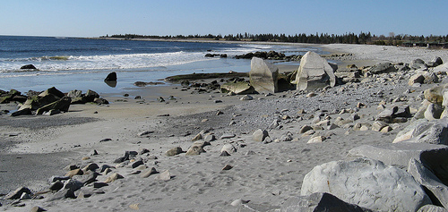
To the west of Ethereal Eclipse, the coast is jagged, dotted with peninsulas, bays, islands, coves, inlets, and shallow coastal pools. Large swathes of the long peninsula extending from the mainland become submerged during high tide, but during the low tide the area retains many saltwater pools. One can count on a number of marine creatures being trapped with the outflow of the tide.
Much of the coast is dotted with rocks and stones, with sandy beaches are present as well. Altogether rugged, the Peninsula marks the beginning of the Bay of Fundy's dominance in shaping the coastal features. Even on this outermost edge of the bay, the tides are fierce, with stark contrast between low and high tide waterlines.
The forest here hugs the coast closely, consisting of extremely tall White Pines that tower over the less predominant Black Spruce. The shore's beaches are often dotted with fallen trees, some of which have been swept into the bay and redeposited with the tide -- sometimes years later. Driftwood is common all along the shoreline. Much of the areas further inland are thickly-forested highlands, with a number of drumlins and even ridges of mountains, where the Mersey River cuts through the North Mountain to drain into the northern bay. The beginnings of the great southern forest in Nova Scotia are found in this area, thick even along the coast.
2. Subterritories
3. Landmarks
3.1 Sea Dog Isle
Sea Dog Isle, located in the Atlantic Ocean near the beginning of the long, narrow western arm of the Digby Neck, is said to be the the location of a thousand treasures. Gypsies and pirates alike used the island to store their wares and treasures. Some just mere trinkets and worthless in the eyes of everyone but the owner, some grand chests filled with rubies and diamonds. There's rumors that the ghosts that owned the booty still dwell in the fog shroud lands and wail all night in search of their forgotten plunder. Unfortunately, said plunder is in a massive sinkhole in the center of the island. This sinkhole, somewhat watery at low tide, floods completely at high tide.
3.2 St. Mary's Bay
A sub-basin of the Bay of Fundy, the bay's southeastern shore is formed by the Fellmoor Swamp and Beast's Grin Peninsula, while its northwestern shore is formed by the southerly half of the Digby Neck (separated from the northern half by the Gut). The tides in this basin are incredibly high, spanning 50 feet (16 metres) in places. The mainland side of the bay houses several hunkering villages in varying sizes. The Neck was not populated in the time of humanity -- it is only a thin strip of beach in some places, no wider than an average-sized home.
The rich and varied flora and fauna of the bays are a result of this tidal action. Regularly exposed swaths of ocean floor create a special environment for the species that inhabit these regions. Tidal action also causes a stirring up of the water, allowing whales to feed easily on agitated plankton.
Cheval Island
Cheval Island is the largest island in the area, just off the tip of the southernmost Beast's Grin Peninsula and just outside of St. Mary's Bay. Cheval Island is easily visible from the coastline. Accessing it requires a low enough tide or a strong swimmer, but getting there is not impossible. The island was not populated in the time of people aside from a single research station which stands in shambles on the southernmost tip.
What has survived from their time, however, are the horses that have roamed the island since the 18th century. Though the horses are small, they are a hardy feral species. Cheval Island horses are generally brown and white in color, with virtually no gray horses among them. There are no more than seventy-five horses roaming the island -- catching and finding them is a daunting task. Cheval Island itself possesses just one freshwater lake, with only enough vegetation to support the small horse population. There are few small mammals or other prey animals aside from the horses -- sea birds frequent the coastland, but beyond that there is little else to be found on Cheval Island.
3.3 Annapolis Basin
Annapolis River
The Annapolis River runs through the Overgrowth Sunrise area, flowing down from the South Mountain area and down the Annapolis Valley. The river flows through some of the most productive agricultural land in all of Nova Scotia. The Annapolis River is a broad and slow-moving river with sediment-rich waters. The area near its headwaters were heavily populated in the time of humanity, including nearby Berwick and Wolfville. Eventually, the river winds its way through rural Beast's Grin Peninsula before emptying into the Annapolis Basin.
Annapolis Royal Generating Station
This tidal power station and rock-fill dam located on the Annapolis River once generated electricity for much of the Bay of Fundy coast in Nova Scotia. Of course, it no longer generates any power -- it has been rusting and rotting for over two decades. Various strange structures and other unique features make it a good place to explore: a tall, skinny tower sits beside a silvery building with a curved facade. It is at once futuristic -- and post-apocalyptic, as the building is in obvious poor maintenance. The blocking of water flow by the dam has resulted in increased river bank erosion on both the upstream and downstream ends. The sluice gates of the dam are permanently opened, reducing the dam's effects on the Annapolis Basin.
Annapolis Basin
The Annapolis Basin is a Bay of Fundy bay on the northern shore of Beast's Grin Peninsula. The Annapolis Basin is named for the river that drains into it at the Annapolis Royal Generating Station. The sheltered and primarily shallow bay is a prime fishing spot year-round. The bay is unique amongst those in the Bay of Fundy -- a long arm of raised land, part of the North Mountain, protects the Annapolis Basin from the ferocious tides of the larger Bay of Fundy. The break in the North Mountain at the northwestern edge of the basin, the Digby Gut, provides an outlet to the Bay of Fundy.
3.4 Digby Formations
Digby Gut
A thin strip of land, part of the Digby Neck, separates the south of Annapolis Basin from the north of St. Mary's Bay. The waters just to to the north of the Digby Neck, known as the Digby Gut, help to protect the Annapolis Basin from tide activity. A narrow passageway of water is all that stands between the Annapolis Basin and the larger Bay of Fundy, but more importantly, the Digby Gut had its origins as the northern terminus of the ancient Mersey River, now a drowned river valley. This allows some of the bay's massive inflow to flood upriver instead of into the bay -- thus softening the tides of the Annapolis Basin.
Strong tidal currents, numerous rocky ledges, frequent fogs and unpredictable winds make the Digby Gut a deadly passage for Luperci sailors. Tide flows give 5 knot tidal currents and create numerous whirlpools and eddies. The gut is about a half nautical mile in width and bordered by high rocky cliffs. The Gut itself marks a break in the North Mountain ridge along the Annapolis Valley and is the eastern end of Digby Neck.
Digby Neck
The Digby Neck, a long and thin peninsula, forms the northwestern shore of St. Mary's Bay and the northwestern shore of the Annapolis Basin. Humans did not populate this area, as swathes of it become submerged during high tide and especially during storms. Nevertheless, a road follows most of the south and north neck, allowing one to travel all the way to the southern tip of the southernmost peninsula.
Mersey River (Mouth)
The Mersey River begins in the Serena Reserve area but enters the ocean in the Beast's Grin Peninsula area. The Mersey River is tidal for the last 9.7 kilometres (6.0 mi) of its length. At high tide, the salt water from the basin flows in and fills the river to a height of up to 26 feet.
These lower parts of the river are picturesque, and the steep forested slopes gave the river's valley the nickname "The Switzerland of Nova Scotia" in the time of humanity. The deeply cut valley, hewn from the contact between slate bedrock on the west and granite on the east, is a drowned river valley of which Digby Gut on the Bay of Fundy forms the northern extreme. At low tide the mud flats, grasses and reeds are very visible. One primary highway bridge spans the Mersey River at its mouth, a short distance from Digby. There are several shorter bridges further inland.
3.5 Digby
This small town hunkers near the shores of the Annapolis Basin and the St. Mary's Bay, boasting only a few decaying streets and quaint houses. Their old construction, coupled with good maintenance during the time of humanity, allows most to remain standing. Some porches and roofs are collapsing, but many of the houses seem untouched aside from busted-out windows and overgrown lawns that have turned to scrubland.
Digby Pines Resort
The Digby Pines, a former seasonal coastal resort hotel, sits along the Mersey River, up and away from the reach of tidal floods. The former hotel includes an 18 hole golf course, long overgrown and gone to seed; a large landscaped outdoor pool, since flooded with rancid water; 30 cottages, most of which stand in varying states of disrepair; and extensive, wooded grounds with a spectacular view of the Annapolis Basin and Digby Gut.
Église Sainte-Marie
This is Catholic house of worship was the largest and tallest wooden building in North America at one point. The church spire rose 58 metres (191 feet) from floor to the cross at the top of its steeple -- though the cross and part of the steeple have since broken off, allowing a small pocket wherein the elements can affect the interior of the church. The interior of Église Sainte-Marie features a high, vaulted ceiling lit by a row of clerestory (high windows above eye level) windows. A band of Romanesque arches runs around the church, above the window. The walls are painted white, and nine flower edged tableaux are painted on the central ceiling vaults. Pews of white oak decorate the interior of the church.
Des Rêveurs

Yeah, it's a picture of a tanker. D8 It's hard to find pictures of beached ships dangit...
Des Rêveurs was one of the largest luxury cruise liners of the early 20th century. After being bruised and battered during a hurricane, its owning company decided to beach the ship as a tour stop. The oceanliner was stationed on the shore of a cove in the Annapolis Basin near to Digby. Its interior was kept in pristine condition for the tourists to see what the life of the rich and famous was like. From the outside it looks like any other old fading piece of history, but the inside still is something magical and breathtaking. Time is beginning to show on the world of Des Rêveurs: The Dreamer, though: rust eats at the side of the ship facing the Annapolis Basin, and its insides are not immune to the humid, cold air. Paint chips and the faint scent of rot can be detected throughout the ship, where wooden furnishings and parts have begun to decay.
Port Royal
Port Royal was an early French colonial settlement, perhaps the start of Digby proper. There are various seventeenth-century styled buildings located south of the town, some of them original and some of them reconstructed. Prior to the demise of humanity, this was a reenactment and historical site, showcasing the French settlers who had once inhabited it. It is therefore starkly different from modernized areas. Many of the buildings, though constructed of wood, are still in good condition. Strong construction and the measures humanity took to preserve the area keeps the buildings of Port Royal standing tall.
4. Likely Encounters
- Something!
5. History
5.1 'Souls
- AniWaya claimed the southernmost part of territory from approximately 2012 to 2013 November.