
Eastern Realms
(redirected from Areas.AshesAndAshes)
|
Areas Page Editors: please follow the Guidelines, whether you are editing an in-game area or World Territory. |
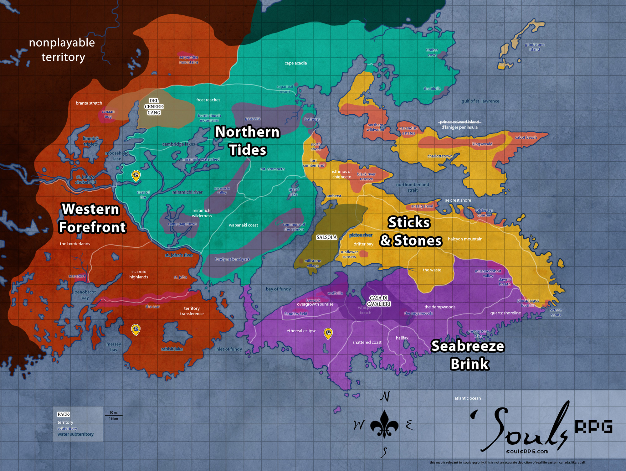
The Eastern Realms formerly encompassed all lands northward of Halcyon Mountain, including the former Bleeding Souls territories, vacated after the 2008 wildfire. Most areas were burned beyond recognition and are still devoid of prey. In 2020, following a blizzard and two earthquakes, the landscape was forever altered.
In September 2020, following the sinking of Death Mountain into the sea, the remainder of Eastern Realms' territories were rolled into the Sticks and Stones forum division.
On this page... (hide)
- 1. Climate
- 2. Geography
- 3. Demographics
- 4. Common Flora & Fauna
- 5. Waterways
- 6. Islands
- 7. Sources
 | |
|
Territories | |
|
Roleplay! | |
1. Climate
The climate tends toward cool and wet. Heavy ice build-up through the Gulf of Saint Lawrence makes for colder winters, though summer can be enjoyably mild thanks to the western strait's warm water flow. The exposed northernmost parts of the peninsula tend to have a rougher, harsher climate than the rest of Nova Scotia. Unlike the southerly portions of the region, there is little fog this far north.
2. Geography
Most of this region is well-above sea level; the terrain ranges from hilly to mountainous. Amongst the mountainous regions is the Death Mountains, with numerous high peaks.
The shoreline is Atlantic; although the water is cold and the waves are strong, the shore lacks the bay coast's extreme tidal range. The Northumberland Strait has a cold current that feeds into Yawrah River. Uniquely, the sea freezes around the northernmost parts and the Northumberland straits.
The land comprised the Bleeding Souls territories, which were used in-game from 2001 until 2008. Now, the land has been irrevocably shaped by the 2008 wildfire, which burned vast swaths of the Ashes and Ashes territory and drove the characters of Bleeding Souls southwards. In 2020, two earthquakes struck the area. While the first, smaller one did considerable damage, it was the second, massive quake which further devastated the landscape.
3. Demographics
This region was sparsely populated prior to the apocalypse. There are no signs of human occupation -- the Concrete Jungle lays in ruins, and what was scattered throughout Aelcrest Shore to the west has been reclaimed by nature. The mountains in particular were unpopulated, and the fire destroyed much evidence of human life further north.
4. Common Flora & Fauna
4.1 FloraUnburned Areas
|
4.2 FaunaExtremely low numbers in the The Blacklands; typical populations elsewhere. |
5. Waterways
Primeval Memories
Vapor Lake
Yawrah River
The Yawrah River begins in the upper parts of the Acheron Peak area, fed by the Tranquil Springs. It snakes down through the mountains and flows across much of the Cape Breton Peninsula, picking up several smaller creeks and streams through its long course.
Its currents are lazy and mild, with little force to them. The danger in the Yawrah is its width. Broad, flat floodplains expand all around the river, which is itself incredibly wide. The territory surrounding the Yawrah River, once green and lush, has become flat and dreary, comprised primarily of floodlands. The trees once lining the river’s borders have been swept away, leaving the soil loose and free to erode. The once quick, clear Yawrah has become muddy and even stinking in the northerly parts, tainted sulphur in the Bonefire caves. Clean water from its many estuaries is enough to purify it in the south.
In the south, however, the floodplains are even wider, and the river slows to a crawl, dominated by the invasive Fanwort plant, a foreign invader to Nova Scotia's soil. Nevertheless, there is still evidence of fish life beneath the surface, and Ospreys and Bald Eagles, fisher-birds, are sometimes seen circling the muddy river, still capable hunters despite the change in the river. Other water-dwelling birds are often seen along the river, though not in any plentiful manner.