
Overgrowth Sunrise
|
Areas Page Editors: please follow the Guidelines, whether you are editing an in-game area or World Territory. |
On this page... (hide)
- 1. Description
- 2. Subterritories
- 3. Landmarks
- 3.1 Cape Split
- 3.2 Annapolis Valley
- 3.3 North Mountain
- 4. Waterways
- 4.1 Minas Basin
- 4.2 Annapolis River
- 4.3 Cornwallis River
- 5. History
- 5.1 Claimed Land
- 6. Sources
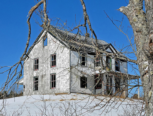 | |
| Credit | archer10@Flickr |
|
General | |
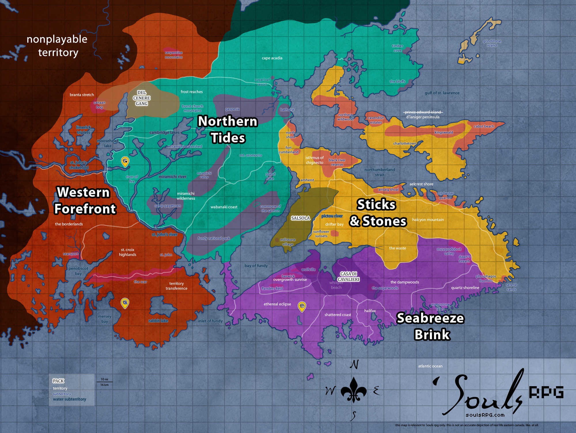
| Region | Seabreeze Brink |
| Subterritories | Berwick and Wolfville |
| Major Waterways | Bay of Fundy |
| Size | ?? sq km / ?? sq mi |
|
Roleplay! | |
1. Description
Two towns once made up much of the eastern parts of this territory. Berwick's small town has become mostly overrun by the wild. To the east, the slightly larger seaport of Wolfville still stands intact. Throughout much of this area, the Annapolis Valley dominates, forming a microclimate that was among the most fertile in Nova Scotia. The coastline here is jagged and tidal, shaped by the tides of the Bay of Fundy. Cape Split, a high point overlooking the narrowest channel in the eastern arm of the huge bay, provides a fantastic vista overlooking the bay and, on fog-free days, the far coast. Deceptively close, crossings in this part of the bay are especially dangerous. The currents are incredibly powerful, with a huge volume of water moving through the narrow channel each day with the changing of the tide.
2. Subterritories
2.1 Berwick and Wolfville
Two towns and their surrounding farmlands once made up the majority of this area, among the most fertile lands in all of Nova Scotia. Higher ridges of elevation surround this valley depression, with the Annapolis River running through its entirety.
2.2 Flander's Fields
On the outskirts of Berwick, Flanders Fields nestles into a corner of the Annapolis Valley. The ancient cemetery is named after the famous fields in Belgium, though it bears little physical resemblance. This once well maintained cemetery has long since become overgrown with wildflowers, weeds, and natural tobacco. Red poppies grow in abundance over its soils, turning the green fields crimson and sanguine. Flanders Fields is said to have the most fertile soil in all the lands, a perfect place for growing just about anything that can be imagined, perhaps due to the interred bodies beneath the ground. If one pushes back the flora, they can find worn down gravestones, slowly turning to rubble over the centuries. A few monuments still stand amongst the overgrown forest, but even these are missing limbs, their engravings chipped and faded.
3. Landmarks
3.1 Cape Split
This tall cliff provides a spectacular sight of the Bay of Fundy and its shoreline. The vantage point of is breathtaking, and one can see clear across the water to Drifter Bay in the north on clear days. If one can find a way down during low tide, they will find a very secluded, narrow beach, with the lands of Cape Split towering above them and an expanse of sandy mudflats, filled with still-moving water and dangerous to walk upon. During hide tide, this beach and the mudflats are completely underwater, which laps at the cliffs of Cape Split.
3.2 Annapolis Valley
The Annapolis Valley, surrounded on the north and south by "mountains," is a long, thin stretch of land, lush with life. Trees are camouflaged by the thick, soft moss and climbing ivy that grows here, along with the wild remnants of former human farms -- the area was once the most productive farmland in all of Nova Scotia. The comparatively mild micro-climate produced by the valley's North and South mountain ranges, as well as its proximity to the waters of the Bay of Fundy make the region ideal for fruit crops such as apples. The entire floor of the ravine is green with moss and fallen leaves. The Annapolis River snakes through the shallow ravine, along with the Cornwallis River to its eastern extremes.
3.3 North Mountain
North Mountain is a narrow southwest-northeast volcanic "mountain" range on the mainland portion of southwestern Nova Scotia, through Overgrowth Sunrise and Beast's Grin Peninsula. As the mountain is ancient, it does not have the sharp, jagged peaks of younger mountains. On the contrary, this mountain range -- much as its southern neighbor in the Ethereal Eclipse -- has been worn to a round peak. North Mountain stretches from Beast's Grin Peninsula to Whisper Beach. It forms the northern edge of the Annapolis Valley. North Mountain rises dramatically from the Annapolis Valley floor and tapers far more gradually to the north and west where it meets the coast. Many parts of this coast have vertical cliffs rising higher than 30 metres, most notably at Cape Split.
4. Waterways
4.1 Minas Basin
The Minas Basin is the easternmost area of the Bay of Fundy. Drifter Bay sits to the north, with The Dampwoods and Whisper Beach to the south. The Minas Basin is defined by the huge headland area in Whisper Beach, known as Cape Split; a narrow channel, known as the Minas Channel, separates the Minas Basin from the rest of the Bay of Fundy.
Sediments in the basin, which are brought in and deposited by tides, range from coarse sand to fine silt and clay -- and contribute to the thick, brown color of the waters. No other coastal marine area has such a large proportion of its floor exposed at low tide. This results in large mudflats at low tide, consisting of thick, sinking bay mud (thick deposits of soft, unconsolidated silty clay, which is saturated with water -- often running) that can easily trap a canine, horse, or other heavy creature.
- Minas Channel
Though one can view the opposite shore from Cape Split on a clear day, the extreme volume of water flowing through the narrow point of the deep, 5-kilometre (3.1 mi) -wide channel Minas Channel makes for incredibly dangerous tides. At mid-tide, the currents exceed 8 knots (4-metre (13 ft) per second). The flow on the north side of Cape Split equals the combined flow of all the rivers and streams on Earth together (about 4-cubic-kilometre (0.96 cu mi) per hour.). - Southern Bight
The southerly area of the Minas Basin, the Southern Bight, has Overgrowth Sunrise to the west and Whisper Beach to the east. The Southern Bight is 59% estuary mudflats, 34% marine flatlands, 7% salt marsh, and less than 1% sandy beach. - Cobequid Bay
The small, narrow piece of the larger Minas Basin that extends into The Waste. The Cobequid Bay, similar to the Shepody Bay in the Chignecto Bay, receives the brunt of the Bay of Fundy's tides. The coastlines are sharp, stark headlands that rise over mudflats -- or just barely contain the baywaters, depending on the tide.
4.2 Annapolis River
The Annapolis River runs through the Overgrowth Sunrise area, flowing down from the South Mountain area and down the Annapolis Valley. The river flows through some of the most productive agricultural land in all of Nova Scotia. The Annapolis River is a broad and slow-moving river with sediment-rich waters. The area near its headwaters were heavily populated in the time of humanity, including nearby Berwick and Wolfville. Eventually, the river winds its way through rural Beast's Grin Peninsula before emptying into the Annapolis Basin.
4.3 Cornwallis River
This long, snaking river meanders between its source on the North Mountain near Berwick to its mouth near Wolfville on the Minas Basin. As most rivers that drain into the Bay of Fundy, it is subject to extreme tides and experiences a tidal bore.
5. History
5.1 Claimed Land
- Annapolis Valley was claimed by Dahlia de Mai from 2008 to 2011 and named the Nevaeh Ravine.
- Partially claimed by the packs Cercatori d'Arte and Casa di Cavalieri from 2011 to 2014.
6. Sources
- Wikipedia:Annapolis Valley
- Wikipedia:North Mountain
- Wikipedia:Annapolis River
- Wikipedia:Cornwallis River
- Wikipedia:Cape Split