
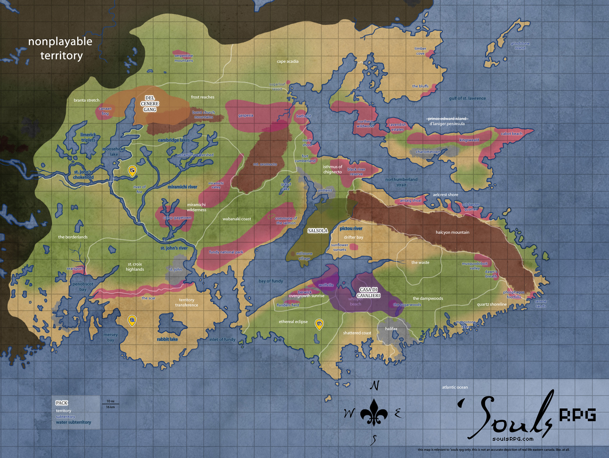
Isthmus of Chignecto
|
Areas Page Editors: please follow the Guidelines, whether you are editing an in-game area or World Territory. |
On this page... (hide)
- 1. Description
- 2. Subterritories
- 2.1 North Shore
- 2.2 Fort Cumberland
- 2.3 Black River Reserve
- 2.4 Amherst
- 2.5 Millstone Village (Salsola)
- 3. Landmarks
- 4. Waterways
- 4.1 Northumberland Strait
- 4.2 Bay of Fundy
- 4.3 Chignecto Bay
- 4.4 Minas Basin
- 4.5 Pictou River
- 5. Islands
- 6. History
- 6.1 Claimed Land
- 7. Notes
- 8. Sources
 | |
| Credit | blender_hassit@Flickr |
|
General | |
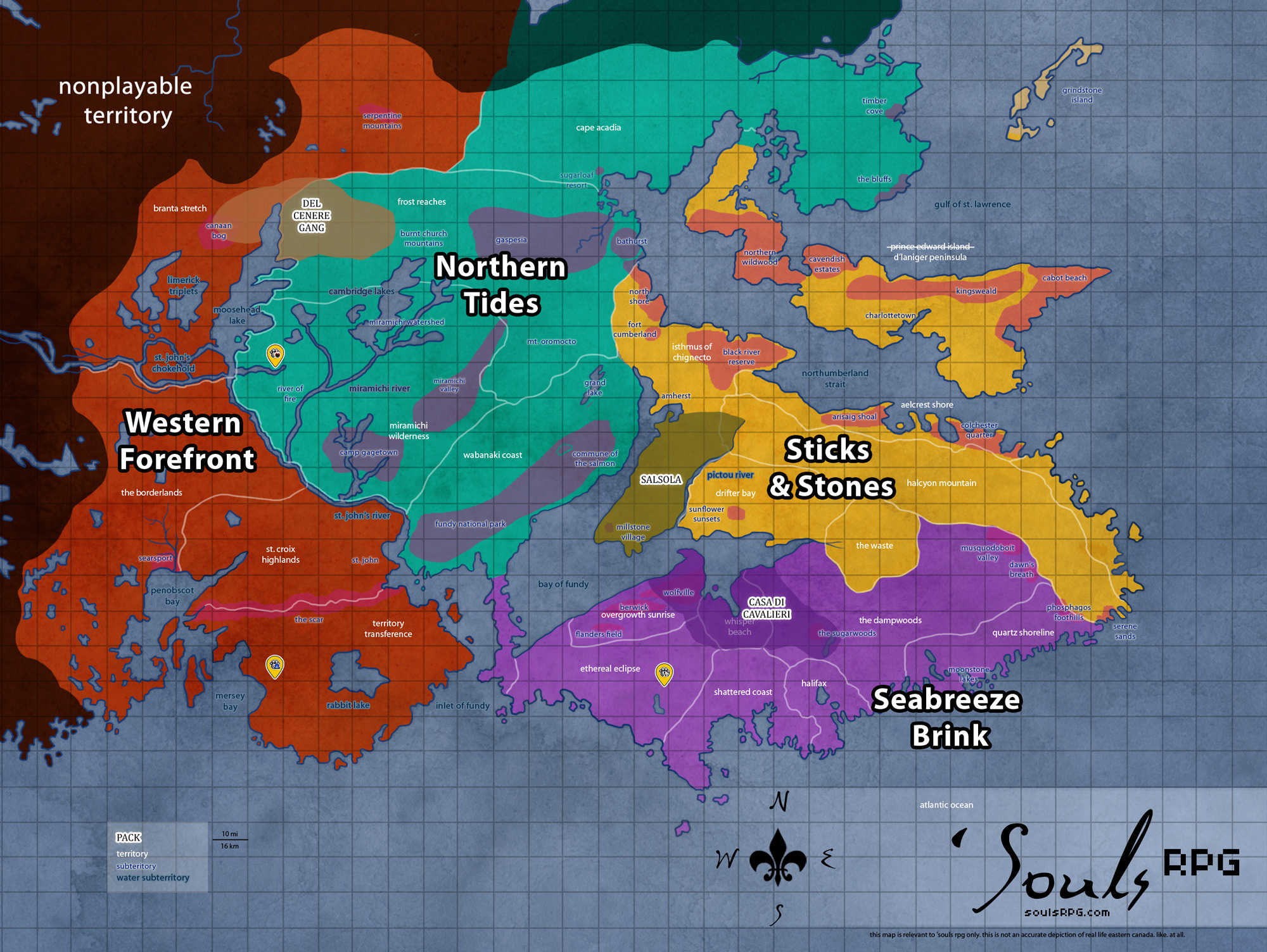
| Region | Sticks and Stones |
| Subterritories | North Shore Fort Cumberland |
| Major Waterways | Northumberland Strait |
| Size | ?? sq km / ?? sq mi |
|
Roleplay! | |
1. Description
The Isthmus connects Nova Scotia with mainland Canada. The land bridge is surrounded by water, bordered on the north with the Northumberland Strait and to the south by the Bay of Fundy. Most of the land here is low and flat -- as much of it is below sea level, it is prone to flooding. In spring, one is hard-pressed to find so much as a footstep of dry ground, and the terrain seems made entirely of mud. The inland areas range from salt marsh to swamp, with a smattering of sparse, piney forest. The most populous area prior to humanity's demise was the city of Amherst, situated around the southerly bay.
2. Subterritories
2.1 North Shore
The North Shore, unlike the Fundy coasts to the far south, is not a coast of incredible tides. On the contrary, most of the currents along the shore are relatively weak, and the tidal range is typical for Atlantic coasts. Most interesting are the numerous barachois formed along the shore -- areas where sand bars have formed, creating salt water lagoons along the shore. The cutting wind has an icy edge as it sweeps down from the far north, and is perhaps the largest danger to those who might seek to land or launch a boat here. Many of the former human communities, although falling to ruin, were fishing communities, sustained by the rich Atlantic Salmon entering the rivers and estuaries of the terrain.
2.2 Fort Cumberland
This fort was built in the mid-eighteen century and became a historical attraction in its later years. Stone barracks still stand, their construction intended to withstand centuries and cannons. The foundations of other buildings remain, though their wooden parts have rotted. Many of the buildings made completely of wood have fallen to ruin; the fort's stone-walled museum still stands, although the roof has collapsed. Much of the surrounding area consists of low, rolling hills and remains devoid of extensive tree growth.
2.3 Black River Reserve
The Black River Reserve, named for the largest of the reserve's numerous rivers, is located along the Northumberland coast. The shore boasts long and rolling sand dunes, along with small barrier islands. Most of the islands are bare of vegetation and become submerged with the high tide -- both the dunes and the islands provide a home for the Harbor and Gray Seal species. The inland park primarily consists of salt marshes, lagoons and sparse coastal forests. Pines and other hardy sorts of trees out-compete most deciduous trees; thus, the area remains green throughout the winter.
2.4 Amherst
The Isthmus connects Nova Scotia with mainland Canada. The land bridge is surrounded by water, bordered on the north with the Northumberland Strait and to the south by the Bay of Fundy. Most of the land here is low and flat -- as much of it is below sea level, it is prone to flooding. In spring, one is hard-pressed to find so much as a footstep of dry ground, and the terrain seems made entirely of mud. The inland areas range from salt marsh to swamp, with a smattering of sparse, piney forest. The most populous area prior to humanity's demise was the city of Amherst, situated around the southerly bay.
Amherst was a large and sprawling town in the time of humanity. Its remnants are a queer mix of early construction -- sprawling Victorian homes and stone churches -- and evidence of rising commercialism -- warehouses and big chain stores. The latter lined the long highways, clashing mightily with the old construction of Amherst on the smaller main streets. One thing both new warehouse and old Victorian share are the signs of natural reclamation -- even in this once-bustling town, signs of human occupation are decaying quickly. Saplings and shrubs sprout from cracks in the asphalt, and the sidewalks slowly lose their battle with the roots of elder trees.
2.5 Millstone Village (Salsola)
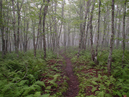
Way down on the southern point of the Isthmus of Chignecto is a small village that cannot be found on a map. In fact, there are literally no roads to Millstone Village at all, only forest paths that stretch and go on for miles. Eventually through the trees there are cabins and a few copses here and there along with tools of the past;none of the technological advances of the world around can be found. From cabins to barns to a one room schoolhouse and graveyard, one can draw the conclusion that Millstone Village is in fact, an Amish village tucked away from the eyes of the world.
3. Landmarks
3.1 Kouchibouguac
This park, located in the north of the Isthmus of Chignecto, includes a variety of coastal features. Barrier islands, sand dunes, lagoons, salt marshes and forests create a pristine wilderness area, completely untouched by humanity save for a few hiking trails and former picnic areas (most of which have turned to deer trails and meadows). The Kouchibouguac provides habitat for seabirds, including the endangered Piping Plover. Colonies of Seals also inhabit the park's 25 kilometres (16 mi) of sand dunes.
3.2 Cape Chignecto Park (Salsola)
This sprawling park boasts unique geological features -- raised beaches, caves and sea stacks litter the coastline. The only buildings in the area are an interpretation centre, picnic area, washrooms and giftshop. These buildings are clustered together near the park's entrance; otherwise, this pristine wilderness park bears no evidence of humanity.
3.3 Tantramar Marshes
The Tantramar Marshes are a major region of Nova Scotia and part of New Brunswick. The marshes were primarily used for the growth of hay during the time of the humans; the flat, open land made it perfect for that purpose. Switchgrass and Bluejoint dominate plant growth, along with scraggly Jack Pine trees. This land extends over The Waste, Drifter Bay, and part of the Isthmus of Chignecto.
4. Waterways
4.1 Northumberland Strait
The shallow Northumberland Strait separates Prince Edward Island from Nova Scotia and New Brunswick. The shallowness of the strait's waters results in very warm summer water -- the Strait has some of the warmest ocean water temperatures on the Atlantic coast north of Virginia. In the winter, however, cold water flowing in from the Gulf of Saint Lawrence cools the water quickly. This is one of the areas within 'Souls playable areas to freeze and display coastal sea ice in winter. Though the channel may freeze entirely, the ice is rarely solid enough to walk across safely.
Central and western coasts of the strait, such as the Isthmus of Chignecto and Aelcrest Shore, as well as the entire south and eastern shore of Prince Edward Island, consist of sandstone. Much of these coasts are beautiful sandy beaches with gentle tides, a stark contrast to the harsh Bay of Fundy coastline to the south. These areas had minimal coastal development in the time of humanity.
4.2 Bay of Fundy
The Bay of Fundy is a large bay of the Atlantic Ocean and part of the Gulf of Maine, separating Nova Scotia from New Brunswick. The bay has a tremendous effect on both provinces coastlines and climates. The upper part of the bay splits into Chignecto Bay in the northeast and the Minas Basin in the east, past Cape Split the Whisper Beach area.
Tides of the Bay of Fundy
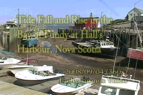
The Bay of Fundy has an extreme range of tide; the highest tidal surge ever recorded occurred in the Minas Basin, a northeastern part of the bay. The water level rose 21.6 metres (70.9 feet). The tides in the Bay of Fundy are semidiurnal (tides that have two highs and two lows each day). The height that the water rises and falls to each day during these tides are approximately equal. There are approximately six hours and thirteen minutes between each high and low tide.
See the tides rise in GIF format (warning: large file).
Features of the Bay of Fundy
Much of the coastline of the bay varies with the tide. Muddy and marshy mudflats contrast against sharply-rising coastal cliffs by low tide. However, the land becomes starkly different during the high tide: the headlands and cliffs disappear, and the water rushes right up to the land.
One of the bay's unique features occurs in rivers that drain into the bay. Tidal bores are common with each change of the tide; tidal bores are "a tidal phenomenon in which the leading edge of the incoming tide forms a wave (or waves) of water that travel up a river or narrow bay against the direction of the river or bay's current."
Additionally, the Bay of Fundy is home to an interesting geologic feature, the Cape Hopewell rock formations, near Saint John. Lastly, much of the water in the Bay of Fundy -- especially within the Minas Basin and Chignecto Bay -- is brown due to large amounts of suspended silt.
4.3 Chignecto Bay
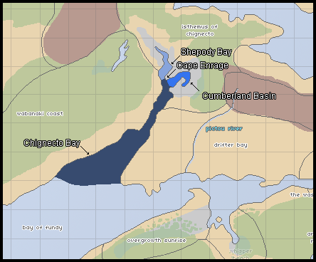
The Chignecto Bay
Chignecto Bay is long, narrow sub-basin of the Bay of Fundy. It extends far inland into the Isthmus of Chignecto area. Wabanaki Coast is to the west and Drifter Bay sits to the east. The Chignecto Bay itself has two separate sub-basins: the Cumberland Basin sits to the east, and the Shepody Bay sits to the west.
- Cumberland Basin
Although the Cumberland Bay's waters are no less dangerous than neighboring Shepody bay, the Cumberland is comparatively calmer. The shoreline is less muddy and more rocky, though copious mudflats are still found throughout the area. The area around the Cumberland Basin was more heavily populated in the time of humanity; the heart of suburban Amherst surrounds the basin. - Cape Enrage
Cape Enrage is the name given to the southern tip of the peninsula that separates the Shepody Bay and the Cumberland Basin. Cape Enrage derives its name from the large peninsula that extends south into Chignecto Bay. This causes the water off the point to become extremely violent, particularly at half tide when more rocks are exposed and the water is moving quickly. - Shepody Bay
Shepody Bay extends far inland. It consists of 77 km2 of open water and 40 km2 of mudflats, with 4 km² of saline marsh on the west. Eroding sand and gravel beaches covering an area of approximately 1 km2 on the eastern shore. A huge number of Shorebirds and other coastal life can be found all along the Shepody Bay. The bay and much of the immediate surrounding coast was designated as a bird preserve and protected wilderness prior to the demise of humanity. Beyond the preserve, the ruins of Amherst's rural outskirts, primarily former farming and fishing villages, huddle against the tide and wind.
4.4 Minas Basin
The Minas Basin is the easternmost area of the Bay of Fundy. Drifter Bay sits to the north, with The Dampwoods and Whisper Beach to the south. The Minas Basin is defined by the huge headland area in Whisper Beach, known as Cape Split; a narrow channel, known as the Minas Channel, separates the Minas Basin from the rest of the Bay of Fundy.
Sediments in the basin, which are brought in and deposited by tides, range from coarse sand to fine silt and clay -- and contribute to the thick, brown color of the waters. No other coastal marine area has such a large proportion of its floor exposed at low tide. This results in large mudflats at low tide, consisting of thick, sinking bay mud (thick deposits of soft, unconsolidated silty clay, which is saturated with water -- often running) that can easily trap a canine, horse, or other heavy creature.
- Minas Channel
Though one can view the opposite shore from Cape Split on a clear day, the extreme volume of water flowing through the narrow point of the deep, 5-kilometre (3.1 mi) -wide channel Minas Channel makes for incredibly dangerous tides. At mid-tide, the currents exceed 8 knots (4-metre (13 ft) per second). The flow on the north side of Cape Split equals the combined flow of all the rivers and streams on Earth together (about 4-cubic-kilometre (0.96 cu mi) per hour.). - Southern Bight
The southerly area of the Minas Basin, the Southern Bight, has Overgrowth Sunrise to the west and Whisper Beach to the east. The Southern Bight is 59% estuary mudflats, 34% marine flatlands, 7% salt marsh, and less than 1% sandy beach. - Cobequid Bay
The small, narrow piece of the larger Minas Basin that extends into The Waste. The Cobequid Bay, similar to the Shepody Bay in the Chignecto Bay, receives the brunt of the Bay of Fundy's tides. The coastlines are sharp, stark headlands that rise over mudflats -- or just barely contain the baywaters, depending on the tide.
4.5 Pictou River
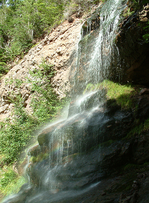
The Pictou River runs over Halcyon Mountain. Cold and fresh water springs forth from somewhere deep within the mountain. During the course of its downstream travel, the river meets a sharp cliff face; it falls well over thirty feet into a deep pool below. The river continues downstream before doing the very same thing over again. This pattern repeats four times down the stretch of the mountain, with rolling and rocky cliffs on either side of the waterfall the whole way down. The lowest waterfall is the only one that is safe to jump, as the drop is a mere ten feet and the pool at the bottom is the largest, but the rest are no less picturesque for their danger.
The Pictou River cuts a swift course between the Isthmus of Chignecto and Drifter Bay, separating the two territories as it travels southward to empty into the Bay of Fundy in the Minas Channel. Due to its location, the lower parts of the river experience a severe tidal bore. The water rushes against the current for a good distance up the Pictou; the lowermost parts of the river are heavily salted and close to brackish for much of the day.
5. Islands
5.1 Isle Haute (Salsola)
This tiny island sits off the Isthmus of Chignecto's coast. Isle Haute, as it was known in the time of humanity, is an impressive island, featuring towering bluffs on the bay side. These protect it from the fierce tides, though the mainland coast is slightly more forgiving. Swimming and boating are possible across the narrow inlet separating the island from Salsola. A steel lighthouse is the only man-made structure. Though unmanned prior to man's extinction, the light has long burned out -- unmanned does not equate unmaintained.
6. History
6.1 Claimed Land
- Salsola has claimed Millstone Village to the present day.
7. Notes
- At its narrowest point between Amherst and Fort Cumberland, the isthmus measures 24 kilometres (15 miles) wide.
8. Sources